Stevington Countryside Walk
To the Windmill - From a peaceful Bedfordshire village to a mill in the surrounding countryside
Google Maps Open Source Maps| Statistics and Files | ||
|---|---|---|
| Start: Stevington | Distance: 6.1 miles (9.8 km) | Climbing: 96 metres |
| Grid Ref: SP 99128 53182 | Time: 3 hours | Rating: Easy |
| GPX Route File | Google Earth File | About Stevington |
| Statistics | |
|---|---|
| Start: Stevington | Distance: 6.1 miles (9.8 km) |
| Climbing: 96 metres | Grid Ref: SP 99128 53182 |
| Time: 3 hours | Rating: Easy |
| GPX Route File | Google Earth File |
Ordnance Survey Explorer Map (1:25,000)
The Walk: Nestling half way down a gentle valley of the River Great Ouse, the village of Stevington has a wealth of old and very attractive honey-coloured stone buildings. These buildings were once used to promote crafts, including lacemaking and the weaving of mats from riverside rushes. At the centre of the village is a 14th century market cross said to feature in John Bunyan's famous book Pilgrim's Progress as the place where Christian's burden fell from his shoulders.
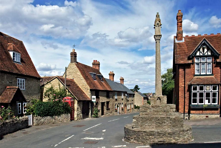 Stevington Cross
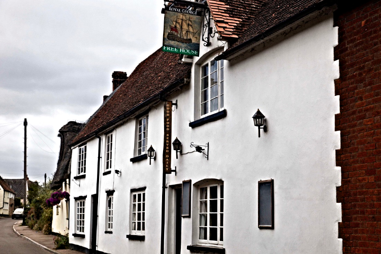 Royal George, Stevington
Below the Church of St Mary the virgin gushes a spring of water reputed to never run dry. This was a place of pilgrimage for people during the middle ages; the water was said to cure eye problems. The area is preserved by the Hunts and Beds Wildlife Trust because of the splendid growth of the wild Butterbur flower. According to tradition, the large leaves of this plant were used for wrapping butter, which is how it got its English name. Inside the church are some remarkable 15th century carvings of animals and men. Two men are lapping from bowls, while two are lounging in as drunken state. These carvings may be linked to church ale, maintained by a gift of seven acres in the 15th century. Beyond the church in Court Lane is another building with religious associations - the Baptist meeting house, built in 1720.
Stevington's restored 1770 postmill revolved on a central pivot and was in full working order until about 1936. Then in 1951 the county council carried out extensive restoration work to celebrate the Festival of Britain. The cloth-coloured sails, which had to be controlled by hand in windy conditions, were replaced in 1957. It is thought an earlier mill known as Miller's Piece stood near Turvey and the railway line, on higher ground.
The walk leaves Stevington and follows the River Great Ouse to West End before returning to Stevington and then heads south-west to Moat Farm where a choice can be made. The featured walk and GPS files head over country fields to Tythe Farm, Northampton Road and Skylark Cottage while a shortcut can be made between Moat Farm and Skylark Cottage by following the old railway line. Either way from Skylark Cottage the finale of the walk visits Stevington Windmill. A fitting end to a lovely walk.
Acknowledgments: Text derived from the Out and Out Series; Discovering the Countryside on Foot. Pictures courtesy of Stevington Village.
Feedback and Suggestions: To suggest a link for inclusion on a this page please complete the Walking Englishman Feedback Form. Thank you.


