Stoer Head Lighthouse, Sithean Mor and Old Man of Stoer
Along Highland's bleak and beautiful coastal paths and cliff tops
Google Maps Open Source Maps| Statistics and Files | ||
|---|---|---|
| Start: Stoer Head | Distance: 5.1 miles (8.2 km) | Climbing: 348 metres |
| Grid Ref: NC 00454 32734 | Time: 3 hours | Rating: Moderate |
| GPX Route File | Google Earth File | About Stoer Head |
| Statistics | |
|---|---|
| Start: Stoer Head | Distance: 5.1 miles (8.2 km) |
| Climbing: 348 metres | Grid Ref: NC 00454 32734 |
| Time: 3 hours | Rating: Moderate |
| GPX Route File | Google Earth File |
Ordnance Survey Explorer Map (1:25,000)
The Walk:
North-west Scotland has few equals to match the wild beauty and rugged grandeur of its coastal scenery. The unspoilt solitude of miles of rocky cliffs, windswept islands, white beaches, spectacular headlands and sea lochs, backed by impressive mountains rising to over 3,000 feet in places, make this region one of the most attractive in Europe for those who are prepared to brave the elements.
Although the area is exposed to the rigours of the North Atlantic climate, there is nowhere more beautiful on a fine day at any time of the year. The walk back to the lighthouse from the Point of Stoer follows a remote section of the coast along impressive sea cliffs, including an impressive sight of the sea stack, the Old Man of Stoer. On the walk there are also superb views northwards to the most distant corner of the British mainland, and south and eastward to some of Scotland's finest hills.
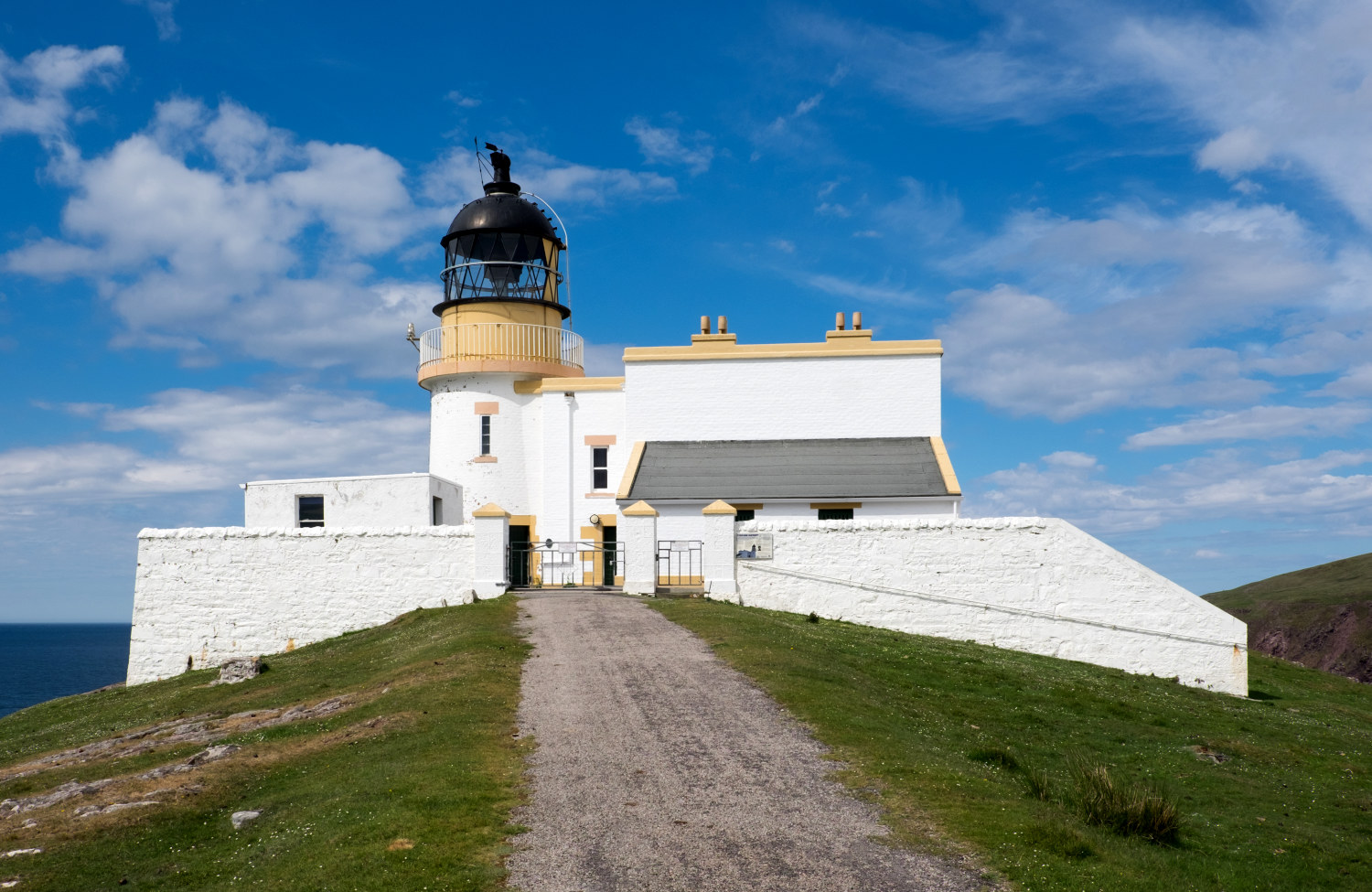 Stoer Head Lighthouse
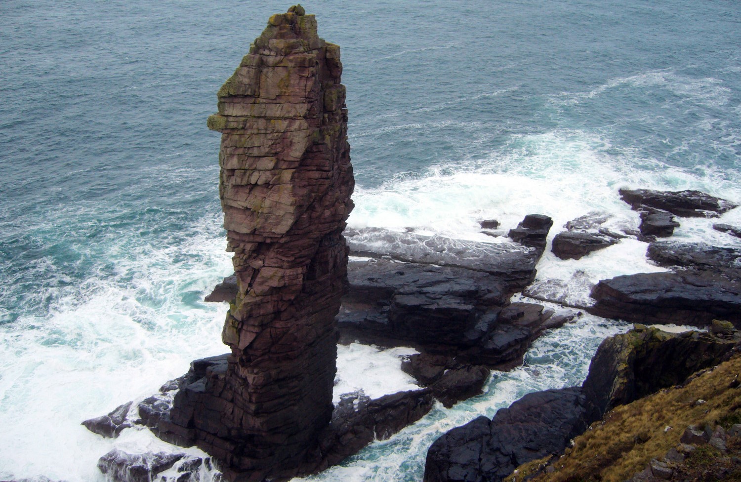 Old Man of Stoer
The approach to the beginning of the walk at Stoer Head Lighthouse is delightful. The B869 which snakes through the coastal hills is an especially scenic alternative route from Lochinver to Kylesku, passing through the villages of Stoer and Nedd and many small crofting communities along the way. A minor road leads off from it towards the Point of Stoer Lighthouse through fertile croft land. This is open and gentle countryside compared to the more usual rock strewn landscapes of Sutherland with its countless lochs and extensive peat bogs.
From the start the walk follows a path leading away from the coast and up to the summit of Sithean Beag with its transmitter pylon helping as a point of reference to aim for. From Sithean Beag take a course to the highest point of the walk at Sithean Mor, 161 metres above sea level. From this highpoint, on a clear day, you can see much including the whole area of the walk. That entire altitude is now lost on the descent down to the Point of Stoer, the outermost point on the walk.
The walk back is now straightforward, by following as close to the clifftops so as to be comfortable while looking out to the coast beyond the cliffs. Naturally the Old Man of Stoer is the star of the show, an impressive stand alone sea stack. It is also a popular rock climbers rite of passage since it was first climbed in 1966 by Brian Henderson, Paul Nunn, Tom Patey, and Brian Robertson.
Apart from the Old Man of Stoer the clifftop walk invites observations of many types of birdlife and flora. Typical birds to be seen include razorbills and guillemots as well as fulmars, kittiwakes, gulls, cormorants and shags. Gannets may also be seen stretching their 6 foot long wingspans into graceful flights and mayby by taking their wings in to make a streamlined dive into the sea from over 100 feet in the air.
Acknowledgments: Text derived from the Out and Out Series; Discovering the Countryside on Foot. Pictures courtesy of Wikipedia.
Feedback and Suggestions: To suggest a link for inclusion on a this page please complete the Walking Englishman Feedback Form. Thank you.


