St Abb's, St Abb's Head and Mire Loch
To a coastal village, along cliff tops to seabird colonies and a quiet loch
Google Maps Open Source Maps| Statistics and Files | ||
|---|---|---|
| Start: Nature Reserve Car Park | Distance: 4.0 miles (6.4 km) | Climbing: 264 metres |
| Grid Ref: NT 91335 67417 | Time: 2-3 hours | Rating: Moderate |
| GPX Route File | Google Earth File | About St Abb's |
| Statistics | |
|---|---|
| Start: Nature Reserve Car Park | Distance: 4.0 miles (6.4 km) |
| Climbing: 264 metres | Grid Ref: NT 91335 67417 |
| Time: 2-3 hours | Rating: Moderate |
| GPX Route File | Google Earth File |
Ordnance Survey Explorer Map (1:25,000)
The Walk: The spectacular cliffs of St Abb's Head provide the setting for an exhilarating walk through one of Britain's most important nesting sites for seabirds. In the summer months, vast colonies of birds congregate here. In 1983, an area of 192 acres was declared a National Nature Reserve, and the sea beneath the cliffs became a Voluntary Marine Reserve a year later. The walk starts from the southern end of the reserve, and after exploring the community of St Abb's, heads north along the cliff tops.
 St Abb's
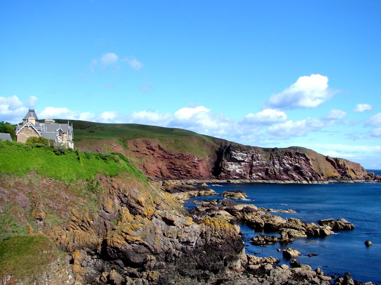 St Abb's Head
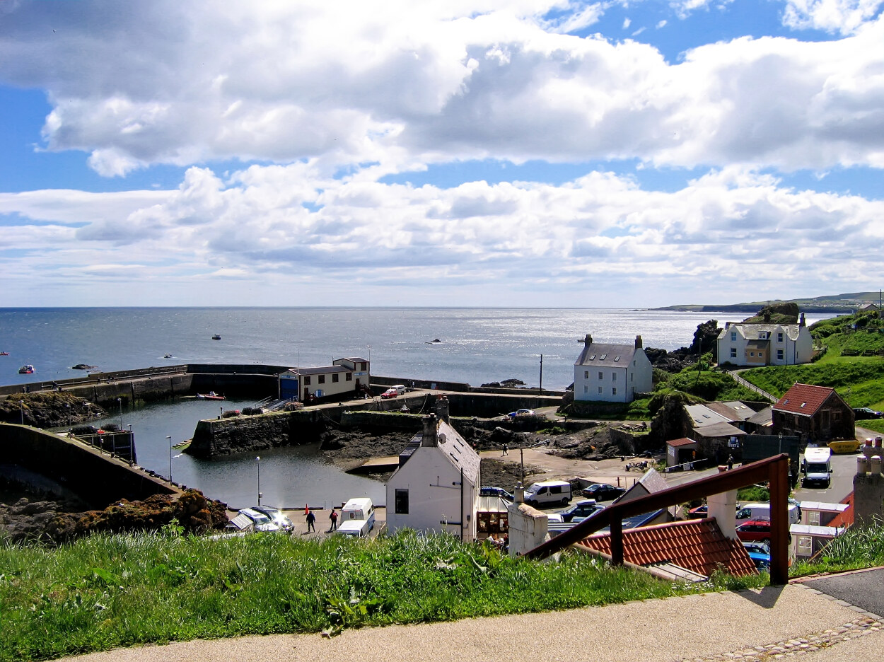
Once in the village of St Abb's which was originally called Coldingham Shore until the change of name in the 1890's. The village of Coldingham lies a few miles inland and the now separate communities are linked by a road and the Creel Road bridleway. Back in St Abb's, take time to explore the village streets and in particular the harbour where the once larger fishing fleet has reduced in size and diversified to include sea angling and diving opportunities for visitors. Some boats still fish the local waters for shellfish including prawns.
The cliffs by the harbour are of a different rock from those to the north, and thus so is the flora. This is the only place on the reserve where you will find bracken, for instance, and associated plants like primroses and early purple orchids. Soon you will pass White Heugh, a rocky promontory and the foretaste of the dizzying heights and inlets further north. Seabirds gather on the south side of White Heugh; mostly guillemots, with a few razorbills and, at the top of the cliff, grey and white herring gulls. Graceful kittiwakes build their grassy nests in crevices on the vertical cliff faces.
On the steep, ungrazed slope on White Heugh's north side; the rare Scot's lovage thrives. Near the path is another rarity, purple milk vetch. In midsummer, six spot burnet moths are found here. Where the path drops down to Burnmouth Harbour, there is a good view of Mire Loch. As you curve round the back of Horsecastle Bay, you can see the submerged forest of kelp at low tide. Further up the shore are common seaweeds, such as bladderwrack.
The black coating on the rocks of the beach is a seawater resistant lichen. Rock surfaces out of the reach of the waves are covered with yellow and green lichens typical of sea cliffs. Also here, are flowering plants such as thrift and sea campion, which can tolerate sea spray. The sward behind the bay is rich in grasses and wild flowers and this is a good area for spotting common blue and meadow brown butterflies. Other butterflies on the reserve include the small copper, the grayling and migrant species such as the Camberwell beauty. There are also large day flying moths and you might see the death's head hawk moth, a spectacular migrant.
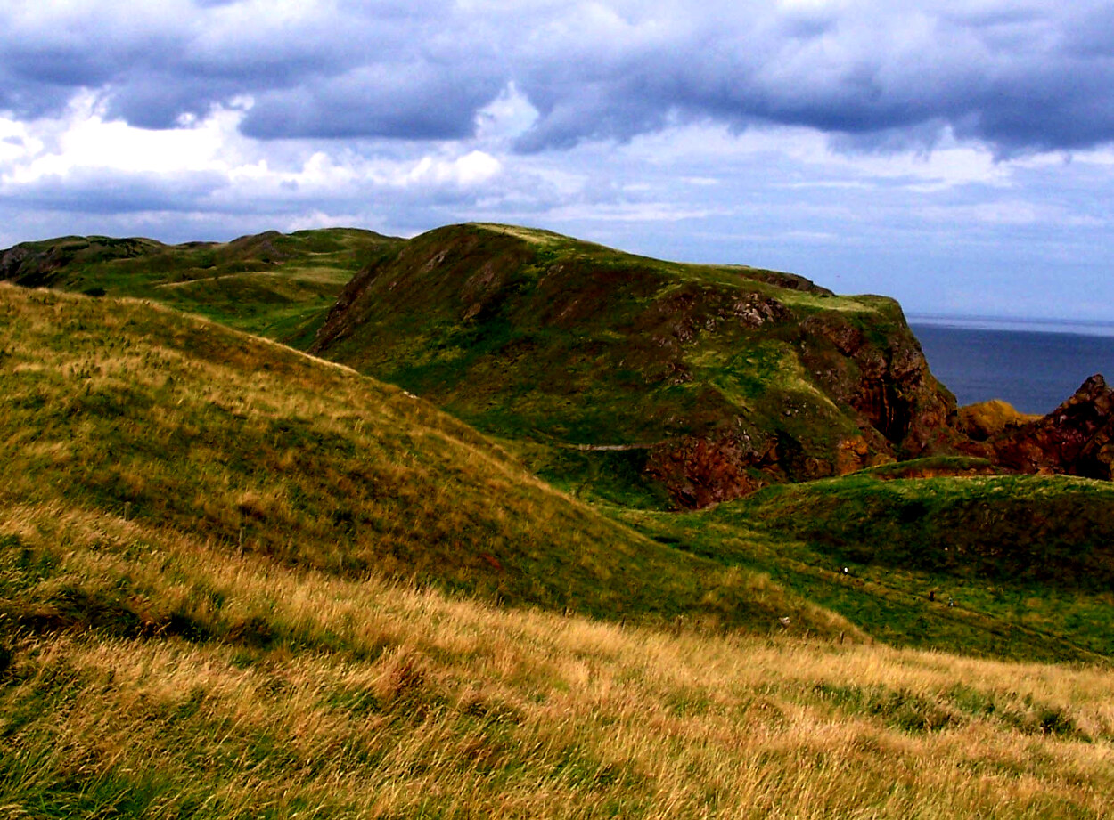
Soon you skirt the south western slopes of Kirk Hill, where an optional detour to the top of the hill always for excellent views of the surrounding landscape and out to sea. Afterwards, the path leads round the cliffs to St Abb's Head, the main objective of the walk, and the lighthouse built on the headland in 1862. The lighthouse is one of the main markers on the approach to the Firth of Forth. On a clear day here you can see Bass Rock, where there is a huge gannetry. On St Abb's Head itself, the greatest concentration of seabirds is on the cliffs and stacks north west of the lighthouse. The majority are guillemots and kittiwakes, but there are also shags. fulmars, herring gulls, razorbills and even small communities of puffins. Shags are present most of the year round, but most of the birds leave around the end of July and do not return until the following spring.
 Kirk Hill
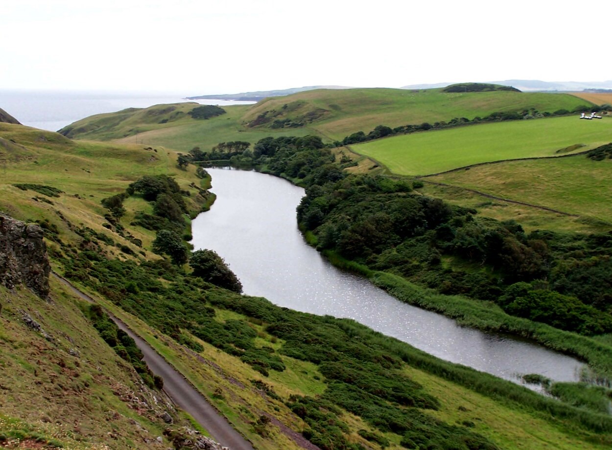 Mire Loch
The ancient volcanic rocks of the headland have formed sheer cliffs and pinnacles with many ledges. These are perfect nesting sites offering access to the sea while being out of the reach of predators such as foxes and mustelids. Guillemots and razorbills in particular need a clear drop into the water because the young leave the nest before they have learned to fly. They tumble into the water and swim immediately, but do not take to the air for several more weeks.
All around St Abb's Head, the sea is very rich in plant and animal life, with an unusual mix of Arctic and Atlantic species. This is due to an eddy of the North Atlantic Drift, which swings around north east Scotland and down the east coast. The clear water and spectacular scenery here make it one of the best sub-aqua locations in Britain. The Voluntary Marine Reserve here was officially opened by Professor David Bellamy in 1984, with the aim of conserving the outstanding biological richness of the inshore waters and to actively encourage responsible educational and recreational use of them alongside the traditional local way of life.
A further round the cliffs is Nunnery Point where a presumed medieval place of worship once stood. Continuing on we reach Pettico Wick where a succession of grey, banded cliffs stretch westwards. These were laid down as mud at the bottom of the ocean 450 million years ago. These sediments have been twisted and contorted by immense geological forces. Many of these headlands have sandy beaches below. The rock here is fundamentally different to that of St Abb's Head which formed around 200 million years later, just 50 million or so years ago. The line between them is an ancient earth movement, the St Abb's Fault. Pettico Wick lies on the fault line.
Leaving the sea behind, the route heads inland to the very different habitat around Mire Loch. Formed by a dam built around 1900, the loch lies in a valley that was scoured out by melt water flowing along the St Abb's Fault as the glaciers retreated at the end of the last ice age. The high crags above the loch contain some rare plants such as spring sandwort and soft clover. Wheatears nest in abandoned rabbit burrows on the lower slopes and mute swans, little grebes and kittiwakes can all by found on the loch.
Acknowledgments: Text derived from the Out and Out Series; Discovering the Countryside on Foot. Pictures courtesy of Wikipedia.
Feedback and Suggestions: To suggest a link for inclusion on a this page please complete the Walking Englishman Feedback Form. Thank you.


