Mugdock Country Park
Strolling through mixed woodland to visit two castles
Google Maps Open Source Maps| Statistics and Files | ||
|---|---|---|
| Start: Car Park | Distance: 3.8 miles (6.0 km) | Climbing: 132 metres |
| Grid Ref: NS 54699 78014 | Time: 2 hours | Rating: Easy |
| GPX Route File | Google Earth File | About Mugdock Park |
| Statistics | |
|---|---|
| Start: Car Park | Distance: 3.8 miles (6.0 km) |
| Climbing: 132 metres | Grid Ref: NS 54699 78014 |
| Time: 2 hours | Rating: Easy |
| GPX Route File | Google Earth File |
Ordnance Survey Explorer Map (1:25,000)
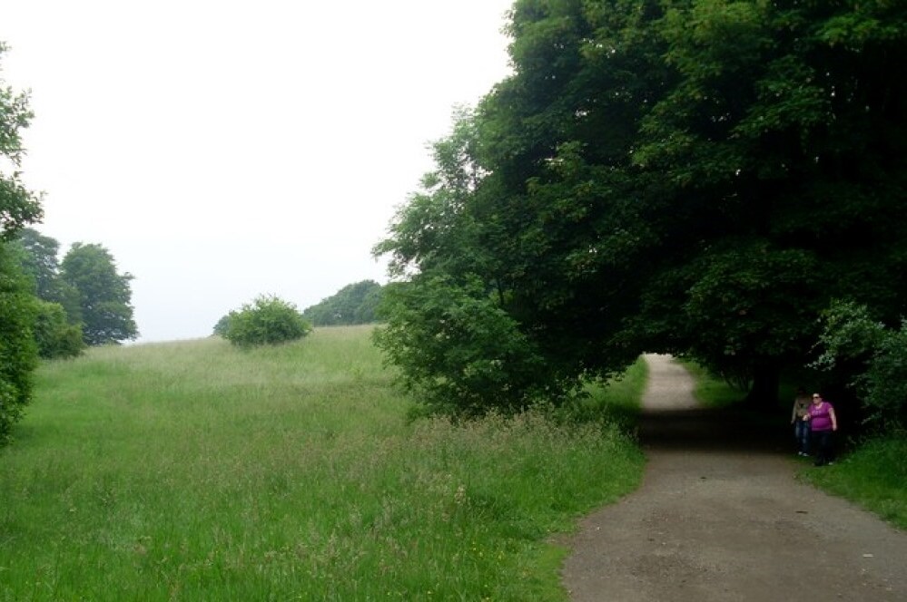
The Walk: Mugdock Country Park is an area of woodland, marshes, lochs and pastures just ten miles from the centre of Glasgow. It boasts a network of good footpaths and bridleways as well as adventure playgrounds, picnic areas and refreshment facilities. The walk begins at the visitor centre car park and heads straight into Pheasant's Wood. At the far side of the wood is a marshy area where rhododendrons bloom in late spring. The route then heads across the open ground of Peitch's Moor and there are good views over Mugdock Loch.
 Mugdock Country Park
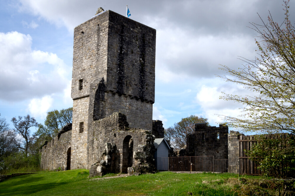 Mugdock Castle
After descending from the moor, the walk skirts around the loch to arrive at Mugdock Castle, occupying a raised site on its western shore. The castle was built in the 14th century by the Graham family, who did great service for Scotland in the continuing struggle with England.
A centre of local power until the 17th century, the castle was sacked by Parliamentary forces when the Graham's sided with King Charles I during the Civil War. Though rebuilt, on a smaller scale, the site never regained its former importance.
A walled garden and a summerhouse were added around 1820, and further demolition and rebuilding took place later in the century before the castle was eventually abandoned. It is now a ruin though partly restored and maintained with the 14th century wall and south-west tower being impressive features.
Beyond the castle is Mugdock Wood, an ancient broadleaved woodland of oak, alder, ash, elm and rowan. it is an SSSI - Site of Special Scientific Interest. Beyond the wood, the route picks up a section of the West Highland Way. This long distance footpath links nearby Milgavie with Fort William, 95 miles to the north. It was officially opened in 1980 as Scotland's first long distance footpath and is now one of the most popular walking trails in the world.
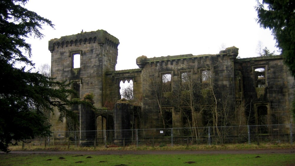 Craigend Castle
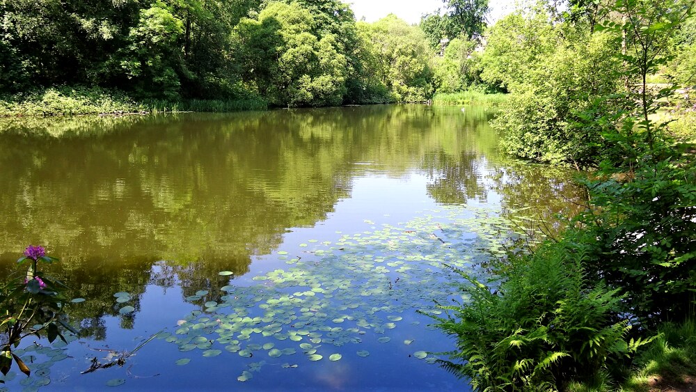 Craigend Loch
After following the West Highland Way through woodland, the route turns right up a minor road to visit Craigend Castle. Unlike Mugdock Castle, this is not a genuine medieval building, but a Gothic fantasy with octagonal square and circular towers complete with embrasures and corbels.
In 1670 the Smith family, as a reward for their longstanding loyal service as blacksmiths and armourers to the Graham armies, were allowed to buy the land on which the castle now stands. Their descendants built Craigend Castle in 1816. Craigend stables, which now house the visitor centre, were built at around the same time.
The last of the Smith lairds died in 1851, and the castle became home to a string of owners and tenants. Between 1949 and 1956 it was the centre of a zoo that claimed to have the 'biggest rat in the world', as well as Charlie, the largest elephant in captivity. The castle is now a shell.
As you head back to the start of the walk, you skirt the eastern side of Gallows Hill, where public executions took place until 1800. Try not to dwell on them as you take refreshments in the visitor centre cafe to mark the end of your walk.
Acknowledgments: Text derived from the Out and Out Series; Discovering the Countryside on Foot. Pictures courtesy of Wikipedia.
Feedback and Suggestions: To suggest a link for inclusion on a this page please complete the Walking Englishman Feedback Form. Thank you.


