Mull of Galloway
Around steep cliffs at Scotland's southern tip
Google Maps Open Source Maps| Statistics and Files | ||
|---|---|---|
| Start: Car Park | Distance: 4.0 miles (6.4 km) | Climbing: 276 metres |
| Grid Ref: NX 15504 30473 | Time: 2-3 hours | Rating: Moderate |
| GPX Route File | Google Earth File | About the Mull |
| Statistics | |
|---|---|
| Start: Car Park | Distance: 4.0 miles (6.4 km) |
| Climbing: 276 metres | Grid Ref: NX 15504 30473 |
| Time: 2-3 hours | Rating: Moderate |
| GPX Route File | Google Earth File |
Ordnance Survey Explorer Map (1:25,000)
The Walk:
The Mull of Galloway has one of the most rugged and dramatic shorelines in the country, and lies between the deep blue waters of Luce Bay and the Irish Channel. The Mull has always been remote. A place of strange beliefs and customs, its history as rich and colourful as the countless wild flowers that carpet the jagged clifftops.
The walk begins from the lighthouse on the tip of the Mull, 269 feet (82 metres) above the thundering seas. Shipwrecks were common on this treacherous coast until the 60 foot (18 metre) high lighthouse was built in 1828 and its piercing foghorn echoed out across Luce Bay.
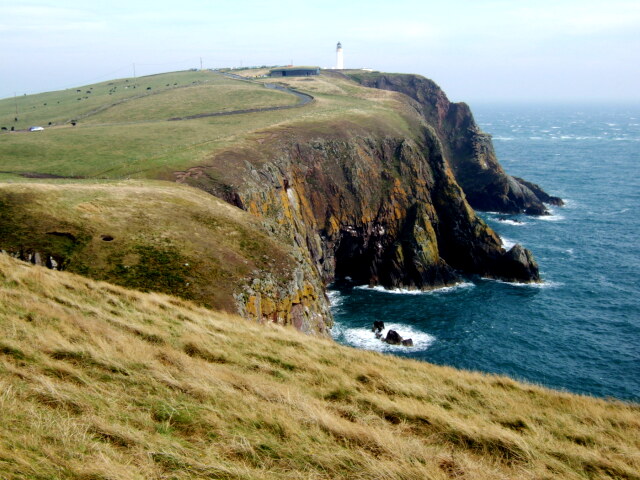 Mull of Galloway
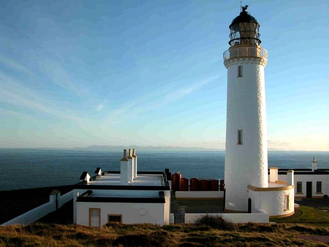 Mull of Galloway Lighthouse
Walking towards Lagvag Point, the view is awe inspiring. It used to be said that you could see seven kingdoms from the headland; Scotland, Ireland, England, Wales, Isle of Man, Strathclyde and Heaven. The narrow cliff ledges and crevices are crowded with raucous herring gulls, great and lesser backed gulls, shags, razorbills, black guillemots and fulmars, which dive and wheel endlessly, twisting in the wind and soaring high above the sheer rock faces.
At nesting time, guillemots use the narrowest, most exposed cliff ledges, safe from four-legged predators. Higher still, kittiwakes build nests of seaweed cemented with mud and coated with droppings. While colonies may overlap, each species individual preferences help avoid too much squabbling.
In the late 1800's, almost the only British colony of fulmars was on St Kilda. The birds rapid spread since then is attributed to modern fishing methods, where offal is thrown overboard at sea. They now haunt the perpendicular cliffs of the Mull throughout most of the year, but close contact is inadvisable as they have a habit of repelling intruders with a foul jet of stomach oil.
Westward along the clifftops, the high ledges are a blaze of colour, with dainty sea pinks, mountain milk vetch, yellow vetch and the pretty star like flowers of spring squill. Years ago, locals scrambled down the dangerous cliff faces in search of rock samphire, rare in these parts, which can be pickled or boiled and eaten with butter - hence it is sometimes known as 'sea asparagus'. In summer, common blue butterflies lay their eggs on birds foot trefoil, while the meadow brown, with its dark eye spots, lays eggs on the healthy grasses.
Far beneath, seals are often seen bobbing and diving in the offshore waters. The Mull's cold, deep currents are excellent fishing grounds; record catches of skate, ling, flounder, turbot and dogfish have been made. Conger eels and even basking sharks are not uncommon sights.
The route continues to East and West Tarbet on either side of a narrow istmuth. The perilous coast beyond West Tarbet was once used as a landing point for smugglers bringing cargoes from the Isle of Man. Many Galloway farms have secret underground passages to the shore.
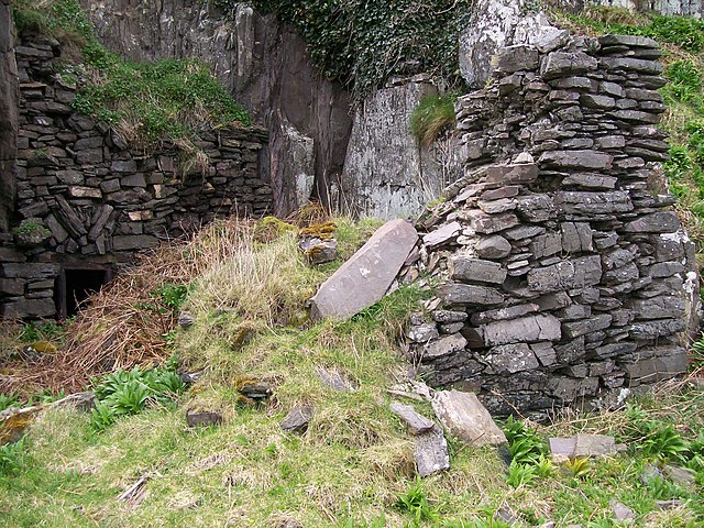 St Medan's Cave
 Cairnie Hill
From the narrowest point of the peninsula, head north to find St Medan's Cave and Chapel. A few pathetic ruins, hidden in the craggy rock face, are all that remains of a chapel. In 1872, the Marquess of Bute organised an excavation here which yielded pilgrim badges, brass mountings and a beautiful sandstone statue of the Virgin Mary, or possibly the saint herself. St Medan, after whom the nearby parish of Kirkmaiden is named, was an Irish princess who fled her own country to escape the attentions of an over amorous suitor.
On the way back to East Tarbet, huge ramparts are evident beneath the grassy banks of the Mull. There is evidence of a hut circle at the south-west end of the ramparts. These double dykes were probably the bastion of a huge fort that may have covered the entire Mull and been one of the largest Iron Age strongholds in Britain.
It was here, reputedly, that the last four members of the Picts, a father and his three sons, were finally conquered by the Scots. They survived siege on the Mull for a week until food ran out when they were forced to strike a bargain. If the Scots would spare the life of Trost, the eldest son, they would disclose the secret formula for heather ale. The father and two other sons could not agree to this so rather than betray his family Trost grabbed a Scot and jumped over the cliff shouting "The secret is saved". Thus the secret recipe for heather ale, a wonderful brew made from sweet scented purple heather, remained a mystery.
Acknowledgments: Text derived from the Out and Out Series; Discovering the Countryside on Foot. Pictures courtesy of Wikipedia.
Feedback and Suggestions: To suggest a link for inclusion on a this page please complete the Walking Englishman Feedback Form. Thank you.


