Kelso - Floors Castle and Roxburgh Castle
A journey through history around the loveliest of Border towns
Google Maps Open Source Maps| Statistics and Files | ||
|---|---|---|
| Start: Floors Castle | Distance: 3.3 miles (5.3 km) | Climbing: 50 metres |
| Grid Ref: NT 70730 346147 | Time: 2 hours | Rating: Easy |
| GPX Route File | Google Earth File | About Kelso |
| Statistics | |
|---|---|
| Start: Floors Castle | Distance: 3.3 miles (5.3 km) |
| Climbing: 50 metres | Grid Ref: NT 70730 346147 |
| Time: 2 hours | Rating: Easy |
| GPX Route File | Google Earth File |
Ordnance Survey Explorer Map (1:25,000)
The Walk: The junction of the River Tweed and River Teviot has long been a meeting of routes. The trade which this generated gave rise to a series of towns, including Kelso, with its cobbled square surrounded by Georgian buildings. Sadly, this has also been a place of battle and siege, leading to the destruction of the once thriving medieval town of Roxburgh and its adjacent castle. On one side of the river valley stands Floors Castle. The original mansion on the site was a plain Georgian country house designed by the famous English architect, Sir John Vanbrugh for the first Duke of Roxburgh, completed in 1721 by the architect William Adam. Between 1839-49 the building was remodelled by the Scottish architect WH Playfair for the sixth Duke. Playfair rebuilt and extended the mansion in a bold castellated style, echoing his earlier design for Donaldson's Hospital in Edinburgh. The remodelled mansion has a profusion of battlements, towers and pepperpot turrets. The additional side pavilions are huge in themselves, and the castle is palatial in scale on a terrace overlooking the Tweed.
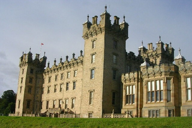 Floors Castle
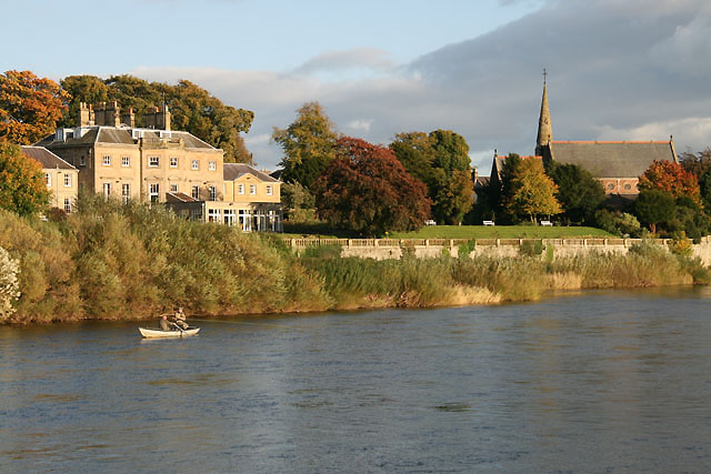 River Tweed at Kelso
The original settlement of Kelso was established by the monks of Kelso Abbey. They developed a market centre on the North Bank of the River Tweed, where the main road from Edinburgh came down to the river. This first settlement, Wester Kelso, has been located by excavation and lies in the grounds of Floors Castle. It was here in 1715 that James Francis Edward Stuart, the Old Pretender, was proclaimed King by the Jacobites. The Mercat Cross remained the location of an annual cattle fair into the 18th century. Today, Kelso is a bustling town, its market square filled with activity. Most of the buildings around the square date from the 18th and 19th centuries, including the octagonal parish church of 1773.
A cluster of older houses dating from the 17th century is located in Abbey Court, opposite the entrance to the abbey. From the other side of the Tweed, there is a good view of Ednam House, one of the finest Georgian mansions in the area, now a hotel. Also from this point, the remains of one of the Abbey's medieval grain mills can be seen.
The River Tweed has always been an unpredictable river. It is deep and liable to sudden spate due to heavy rain in its upland source areas. A stone bridge spanned it in medieval times, but after this was destroyed, the only bridge over the Tweed above Berwick was the one at Peebles. In 1754, a new one was built, close to the abbey and Kelso, but this was swept away by a flood. In 18O3 it was replaced by the present bridge, which still carries traffic across the river. Built by the famous engineer, John Rennie, it served as his model for the old Waterloo Bridge in London (which is no longer in existence), and features pairs of classical columns above the cutwaters. Below it a weir and a stream run to a mill beside the junction of the two rivers on the site of one of the medieval mills of Roxburgh.
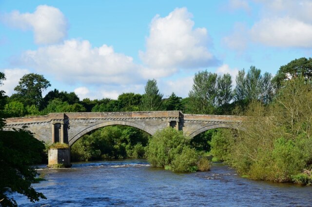 Teviot Bridge over the River Tweed
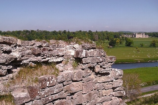 Ruins of Roxburgh Castle
In the 13th century the Royal Burgh of Roxburgh was one of Scotland's largest and most important towns. It had become a centre for the thriving trade which had grown up adjoining the castle. In the mid 12th century, a new burgh was laid out on the eastern side of the existing settlement. The two communities grew and merged to form a single walled town which had several stone churches, friaries and schools. During the early 14th century, when the town was in English hands, the earthwork defences were rebuilt in stone.
The town was alternatively in English and Scottish hands throughout the 14th century, before being finally recaptured by the Scots in 1460. The devastation caused by constant warfare led to the town's decline, and today there is nothing left to see on the surface that marks the location. Excavations at Springwood Park have located the site of an early suburb.
Roxburgh is the most impressive medieval castle site in the Scottish borders. It consists of an elongated mound nearly 80 feet high, which dominates the junction of the Tweed and Teviot. The mound is a 'Kame', a deposit of sand and gravel laid down by glacial meltwater. From its summit, there is a fine view of Floors Castle and Kelso. First recorded around 1128, it was one of the strongest fortresses in the whole Border region. It had a vital strategic location commanding the first main crossing point of the Tweed above Berwick. Because of this, it changed hands several times between the Scots and the English.
It was finally recaptured by the Scots with the loss of James II, who was killed by the bursting of one of his own siege guns. The castle was then left to fall into ruin, but the site was occupied again during the English invasions of the 1540s when the Earl of Hertford had a new artillery fortress constructed. When peace was finally restored between Scotland and England, the stronghold was demolished under the terms of the Treaty of Boulogne. The stonework that remains mainly relates to this 16th century castle.
Acknowledgments: Text derived from the Out and Out Series; Discovering the Countryside on Foot. Pictures courtesy of Wikipedia.
Feedback and Suggestions: To suggest a link for inclusion on a this page please complete the Walking Englishman Feedback Form. Thank you.


