Worth Matravers, Seacombe Cliff, Dancing Ledge and Priest's Way
A breathtaking coastal walk through time amongst the Purbeck quarries
Google Maps Open Source Maps| Statistics and Files | ||
|---|---|---|
| Start: Worth Matravers | Distance: 5.2 miles (8.5 km) | Climbing: 193 metres |
| Grid Ref: SY 97438 77669 | Time: 3 hours | Rating: Moderate |
| GPX Route File | Google Earth File | Isle of Purbeck |
| Statistics | |
|---|---|
| Start: Worth Matravers | Distance: 5.2 miles (8.5 km) |
| Climbing: 193 metres | Grid Ref: SY 97438 77669 |
| Time: 3 hours | Rating: Moderate |
| GPX Route File | Google Earth File |
Ordnance Survey Explorer Map (1:25,000)
The Walk:
With magnificent views throughout its length, this walk takes in some of the most spectacular coastal scenery in southern England. Worth Matravers lies in a sheltered position about a mile from the sea.
Today it is a tranquil village of charming stone cottages, but Worth Matravers has a long and interesting history. Called 'Wrde' in the Domesday Book, the village was clearly well established in Norman times. The name Matravers results from this land being owned by the Matravaux family until the 14th century.
There is further evidence of medieval occupation in the nearby strip lynchets, remains of terraced fields cultivated in those days, on the hillsides above Winspit Bottom. Worth Matravers was chiefly known, however, as the centre of the Purbeck stone-quarrying industry.
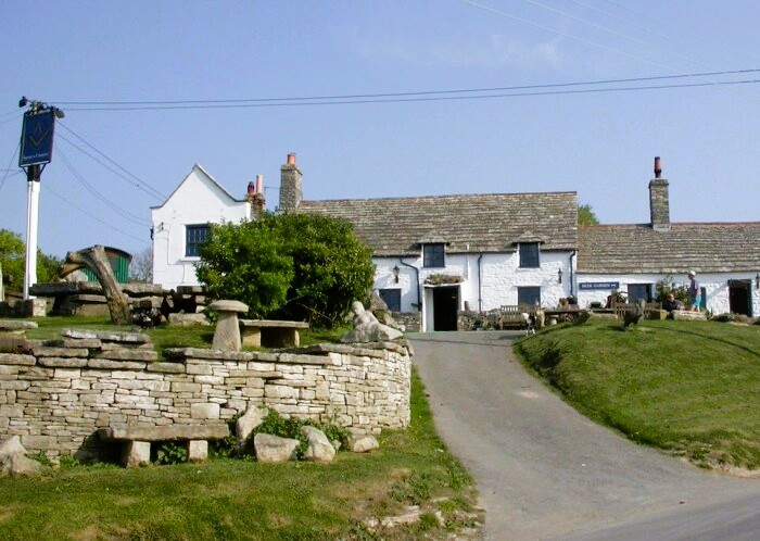 The Square and Compass, Worth Matravers
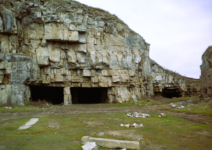 Winspit Quarry
The stony path from Worth to Winspit is notable for the great variety of flowers along the verges. Dog rose, vetches, field scabious and rosebay willowherb mingle with coastal species such as sea bindweed, bugloss and red valerian. Honeysuckle and old-man's beard climb up the shrubs of elder, blackthorn and hawthorn.
Now disused, Winspit is the oldest of the local quarry works. It was also the most productive, and was worked until the early 1950's. Stones was taken both from the cliff face and from the broad galleries going deep underground. Quarried stone blocks were lowered up to 30 feet from the man-made plateau above the cliff face into flat-bottomed barges waiting below. Two smaller galleries below the clifftop to the east of the bay, now provide a home for a colony of rare horseshoe bats.
On the 6th of January 1786, in violent storm conditions, the East Indiaman Halsewell was driven into the bay between Winspit and Seacombe. The vessel broke up on a submerged ledge beneath the undercut cliffs, and the captain was drowned, along with 187 others. In a dramatic rescue by local quarrymen, 82 survivors, who had struggled to a rock above the waves, were hauled up the cliff face to safety. This tragic drama took place at a point almost immediately below the small open-cast quarry, or 'ridden-hole', to the left of the path, a half-mile east of Winspit. On the eastern rim of the pit, a giant ammonite fossil has been exposed.
At Seacombe, gaping galleries plunge deeply below ground in the largest of the cliffside quarry workings. Blocks weighing up to 15 tons were hewn out from here. In places, the gallery ceilings reach a height of 13 feet. The site is now a popular spot for budding rock climbers to learn their sport.
Just off the path on the east side of Seacombe Cliff stands what appears at first to be an igloo tent, pitched upon an exposed site. Closer inspection reveals this to be a metal turret, installed in 1940, where a lone machine gunner had the unenviable task of protecting this stretch of coast from potential air and seaborne attack.
At Hedbury Quarry, stone was extracted from caves on two levels. Founded in the 18th century by the Eidbury family, from whom their name derives, the workings are accessible only via a steep track. The quarried stone had to be shipped out on barges brought alongside the treacherous cliff face below. The site of the derrick used to lower the stone blocks remains visible.
The seaward facing cannon here is a 12 pounder of the Napoleonic Wars, though the circumstances of its presence on the site remain a mystery. This secluded area is home to a large colony of rabbits, and flowers such as blue fleabane, viper's bugloss and wild carrot.
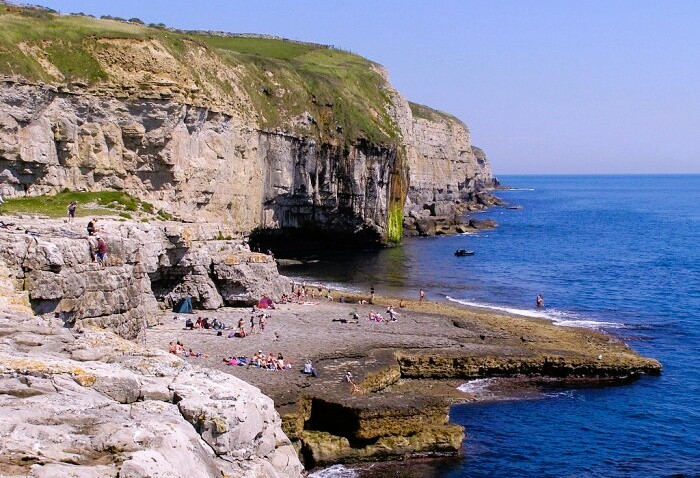 Dancing Ledge
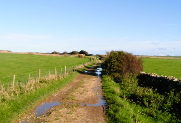 Priest's Way near Worth Matravers
Dancing Ledge is one of the few points on the walk with direct access to the tideline. The cave created by the quarrymen on the landward side of the cove now shelters a colony of bats. Thomas Pellat, headmaster of the nearby Durnford House School, had the tidal bathing pool blasted out of the solid rock in the late 19th century.
The ledge itself, a broad plateau projecting into the sea, is deeply rutted where quarried stone was carried by hand-cart to the water's edge for loading. This was a popular spot for smuggling activities because contraband cargoes could readily be hidden in the caves.
The Priest's Way, which you follow on the way back from the coast, is an ancient drove road running for the most part between dry stone walls. Its name dates back to the Middle Ages when the priest from the prosperous parish of Worth Matravers would trudge across country to perform services in Swanage, which was then a tiny fishing village.
On a clear day, there are superb views eastwards from the Priest's Way to Swanage and the Isle of Wight. Some quarrying is still carried out in the area, and as you return to Worth Matravers, you pass a recently exposed open-cast pit on your right. Finally, when back in the village, the Square and Compass pub is a popular place to stop for refreshments.
Acknowledgments: Text derived from the Out and Out Series; Discovering the Countryside on Foot. Pictures courtesy of Wikipedia.
Feedback and Suggestions: To suggest a link for inclusion on a this page please complete the Walking Englishman Feedback Form. Thank you.


