Widecombe in the Moor, Hameldown Tor, Grimspound and Natsworthy
Through high moorland scenery to a remarkable prehistoric site
Google Maps Open Source Maps| Statistics and Files | ||
|---|---|---|
| Start: Widecombe in the Moor | Distance: 7.2 miles (11.7 km) | Climbing: 363 metres |
| Grid Ref: SX 71861 76816 | Time: 3 hours | Rating: Moderate |
| GPX Route File | Google Earth File | About Dartmoor |
| Statistics | |
|---|---|
| Start: Widecombe in the Moor | Distance: 7.2 miles (11.7 km) |
| Climbing: 363 metres | Grid Ref: SX 71861 76816 |
| Time: 3 hours | Rating: Moderate |
| GPX Route File | Google Earth File |
Ordnance Survey Explorer Map (1:25,000)
The Walk:
Widecombe on the Moor, where the walk begins, has been made famous by the song 'Widecombe Fair' and its account of the doings of Uncle Tom Cobley and all. The fair is still held on the second Tuesday in September. The place would certainly be a popular tourist spot even without the well known song, for it typifies the charm of the Dartmoor village. Sitting in a hollow surrounded by moorland, Widecombe's village green, with an inn and an old smithy, is overlooked by the tall granite tower of the Parish Church of St Pancras.
There is the same monumental solidity inside the church, typified by the monolithic pillars of the nave, but its chief glory lies in its ornate roof bosses. Some are carved with complex geometric patterns, others show plants and animals. Three one eared rabbits chase each other around a ring, while a tethered scapegoat looks suitably miserable. An angel looks across, perhaps with an air of disapproval at a green man, an ancient fertility symbol.
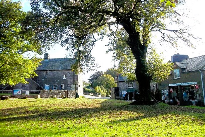 Widecombe in the Moor
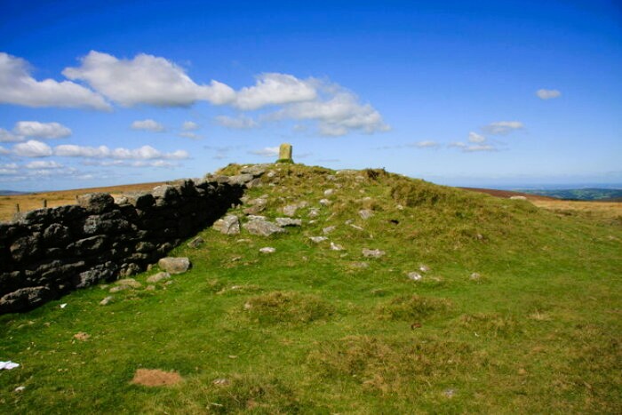 Hameldown Beacon
The walk begins by following a quiet country road, with a clear little stream gurgling alongside, but soon turns off along a surfaced road to climb Hamel Down. The road is bordered by stone walls, roughly fashioned from granite boulders. Growing on top of the walls are old gnarled trees, with their roots spread out over the stones.
As you climb, a fine view opens up behind you. Widecomee and its church tower surrounded by a patchwork of small fields, and rough moorland and hilltops beyond, bristling with shattered rocks.
The stone walls bordering the lane give way to high grassy banks, and bracken begins to invade. The road becomes a rough track and its cover of sandy earth grows thinner, eventually revealing impressive flat slabs of rock underfoot. Over the centuries, stones of this sort have been used to build everything from humble barns to grand houses.
The path ends at a farm gate where the moorland proper begins. The route leads through a grassy hollow in an area of short cropped turf, colourfully dotted with heather and gorse, and grazed by ponies and sheep. A few stunted trees and bushes have survived on these windswept uplands. A wall made up of massive blocks, some as much as six feet long, as well as smaller more rounded stones, marks the farm boundary. Across a deep combe to your right, Kingshead Farm sits in a lonely spot high up on the moor. The path crosses a little ridge and drops down to the stone walls that mark the upper limits of the farms of the next valley.
The path changes direction again for the final ascent to the top of Hamel Down. This is a lovely section of moorland, richly coloured with gorse and heather. A line of beech trees, their branches bent by the prevailing winds, reach over to form a canopy for the little stream that rushes downhill beside the path over a series of small falls.
As you ascend, the stream narrows until it becomes no more than the succession of trickles draining off the moor, and rocks begin to poke through the thin surface soil. Great lumps of granite sparkling with mica, and coloured by felspar, are mixed in with occasional chunks of crystalline quartz. This is a very lonely patch of moorland, with sheep, ponies, and the occasional hovering kestrel, your only company.
Where the trees come to an end, they are replaced by a stone wall of truly massive boulders and slabs. Whinchats, summer visitors here, are especially fond of the wall-top perches. At the sight of a walker, they fly on uphill, displaying their white patched tails, until eventually they decide they have reached a safe distance and find a new perch.
At the top of Hameldown Beacon is a cairn and a stone dated 1854. From here there is a magnificent panoramic view. To the west is the rolling moorland of central Dartmoor. Eastwards is a high ridge, whose outline is marked with the broken slopes of the tors; beyond it are the more massive rocks of Haytor. The sea is visible to the south, beyond a line of hills, and to the north are the gentler hills and the lush green farmland of central Devon, brightened in patches by the rich, red earth of ploughed fields.
The walk follows the ridge along the top of Hamel Down. Where the wall swings away to the left is the first of a series of prehistoric burial mounds. Two Barrows - though only one is now obvious - is a typical round barrow, a massive circular mound with traces of a ditch outside, characteristic of the Bronze Age. Beyond it is a more decayed single barrow, but by far the most impressive can be seen on the horizon, the aptly named Broad Barrow.
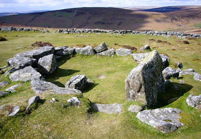 Grimspound
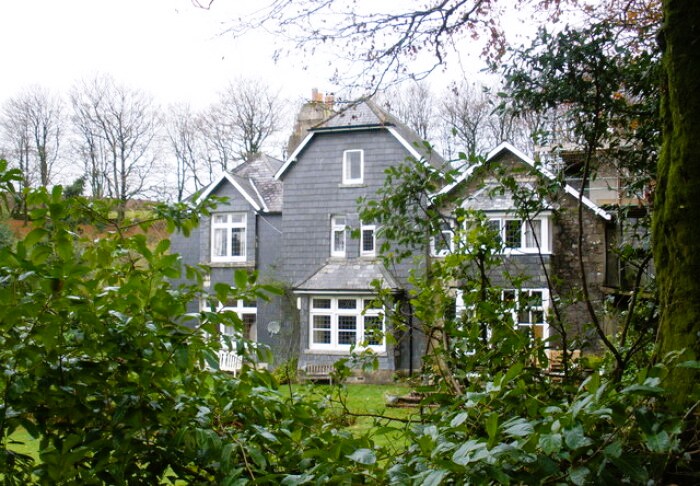 Natsworthy Manor
At 1,745 feet (532 metres), this is the high point of the walk. Beyond it, a cairn marks the end of the ridge, and the path heads steeply downhill. Soon, the great circular enclosure of Grimspound comes into view below you.
The atmospheric remains of the Bronze Age settlement known as Grimspound provide a fascinating glimpse into the lives of the people who buried their dead in the great round barrows on the top of Hamel Down. Though today this is a lonely and inhospitable place, difficult to farm, some 3,000 years ago its prospects were different. The slopes were relatively easy to clear for pasture, and the thin soil suited the crude tools of the day.
The people who lived here probably grew a few crops, but the bulk of their diet consisted of meat. They grazed cattle on the slopes in the summer, and kept them in a compound in the winter. The compound was surrounded by a substantial stone wall. Even the remains of this are impressive; in places they are three feet (1 metre) high and ten feet (3 metres) thick. The entrance can still be made out, with tall stones flanking a pavement of stone slabs.
Within the compound were around 20 circular houses with low stone walls. These would have been topped by conical roofs, constructed of thatch, possibly bracken and heather, each supported by a central pole. The walls, complete with entrance passages curved to provide some shelter from the wind and rain, are still in evidence.
Some of the houses have survived better than others. Inside the best of them, you can still see central stones that supported the roof pole. Domestic details such as cooking holes and stone shelves, which would probably have supported primitive bedding arrangements, are also clearly visible.
The path from Grimspound is a broad sandy track across an otherwise empty and expansive heather moorland. Ponies, which seem quite unconcerned by the presence of walkers, are your only company here. To the right of the track stands a tall stone memorial, which bears a carved inscription on one side, and on the other a plaque explaining that it was here on the 22nd of March 1941, that an RAF bomber crashed while returning from France, killing the crew.
The path leaves the moor at this point, going steeply downhill and past the edge of a conifer plantation to join the quiet country lane that runs back to Widecombe.
Initially, the lane runs between stone walls topped by slender birch trees. Having entered an area of woodland, it passes a grand house, Natsworthy Manor, whose walls are hung with slate. Just beyond Natsworthy, the road bends past a delightful thatched cottage.
The intimacy of the lane, with trees rearing up from the walls, is in stark contrast to the open footpaths of the moor. At times, the banks reach well above head height. They are topped in places by stone walls and elsewhere by beech hedges cut into perfect box like straight lines. The hills on either side also display great contrast. To the right is the gentle rise of Hamel own. To the left, the more jagged outlines of Honeybag Tor and Chinkwell Tor, where the rocks have erupted through the crests of the ridge.
You go steadily downhill and as you do so, the character of the country begins to change. The fields are altogether lusher and greener, and the farms more closely packed together. Occasionally the regularity is broken by patches of rough grass and by massive boulders, two troublesome for the farmers to clear.
The road runs in and out of areas of woodland. Their green depths are a wilderness of tall ferns and mossy boulders. Beech and birch trees lean their branches over the road to create a green tunnel, and between the trees there are glimpses of farm houses set comfortably against the slopes of the hill.
The road crosses a brown peaty stream, East Webburn River, that tumbles down from the moorland, and you leave the woodland. Almost hidden behind a plantation of conifers and ornamental trees is the elegant, whitewashed Wooder Manor, now a hotel. Finally, the tall tower of Widecombe church appears ahead, and you return to the village green. Perfect timing for refreshments in the Old Inn, Widecombe's ever popular pub.
Acknowledgments: Text derived from the Out and Out Series; Discovering the Countryside on Foot. Pictures courtesy of Wikipedia.
Feedback and Suggestions: To suggest a link for inclusion on a this page please complete the Walking Englishman Feedback Form. Thank you.


