Axbridge, Cheddar Yeo, Crook Peak and Wavering Down
Two different landscapes around a historic town
Google Maps Open Source Maps| Statistics and Files | ||
|---|---|---|
| Start: Axbridge | Distance: 7.6 miles (12.3 km) | Climbing: 297 metres |
| Grid Ref: ST 43127 54560 | Time: 3-4 hours | Rating: Moderate |
| GPX Route File | Google Earth File | The Mendip Hills |
| Statistics | |
|---|---|
| Start: Axbridge | Distance: 7.6 miles (12.3 km) |
| Climbing: 297 metres | Grid Ref: ST 43127 54560 |
| Time: 3-4 hours | Rating: Moderate |
| GPX Route File | Google Earth File |
Ordnance Survey Explorer Map (1:25,000)
141 Cheddar Gorge, Mendip Hills, Wells and Glastonbury
153 Weston-super-Mare and Bleadon Hill
The Walk:
The western end of the Mendip Hills, beyond the Cheddar Gorge, erupts out of the flat, alluvial plain of the Somerset Levels to provide a stark contrast in land use and scenery. The lush pastures of the levels are separated by ditches and drains, rather than hedges. This gives the impression of one great field stretching to the horizon. The hilltops are wild and unspoilt. They did not suffer from the mining for lead and coal that scarified the hills further east; apart from the occasional limestone quarry, they have been used only for rough pasture.
This work explores both areas, and starts from the market town of Axbridge, which lies between them. Axbridge was an important town in Saxon times, and in the 11th century housed a royal mint. In the Middle Ages, it became very prosperous on the back of the wool trade, and still retains much of its medieval shape and character. It was made a conservation area in 1970.
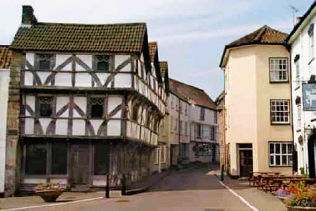 Axbridge Square
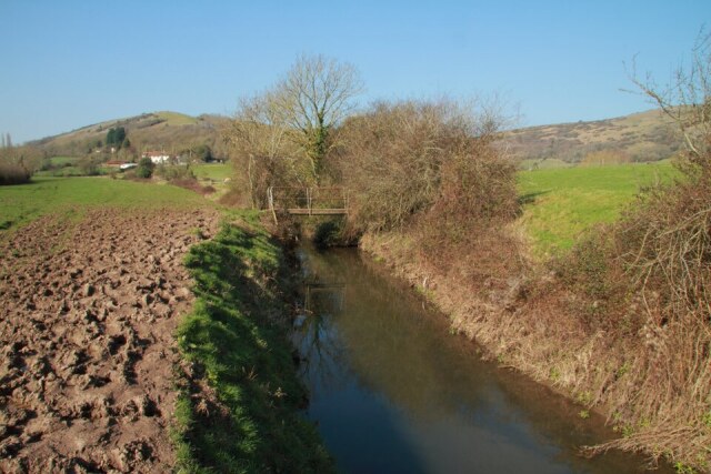 Alongside Cheddar Yeo with Crook Peak ahead
The walk begins in The Square, a marketplace over 1,000 years old, which boasts several pubs and hotels, and a modest 19th century Town Hall. In one corner is half timbered King John’s Hunting Lodge, now a museum. This merchant's house postdates John by some 300 years. It got its name from the carving of a king's head on the corner - actually a pub sign from the 17th or 18th century - and from the factor that John was known to have hunted the Royal Forest of Mendip.
You leave along the High Street, past the handsomely tiled butcher’s shop. Several jettied half-timbered buildings, masked by later frontages, mingle with interesting Georgian houses along the street.
The wolk turns off past the aptly named Townsend Farm to cross the Levels. The arrow-straight path, Prowse Lane, runs alongside a rhyne, as the drainage ditches that cross this low lying land are known, to the Cheddar Yeo. The Yeo and River Axe once sprawled across this area, regularly flooding it. Works in the early 19th century straightened their courses and integrated them into the system of ditches and rhynes.
A path along the riverbank takes you through quiet green fields to a footbridge, where you cross to begin the climb onto the Mendips. In the combe to the right nestles the peaceful farming village of Compton Bishop. You are almost on the level with the tower of the church, which, while earlier and less spectacular than some, exhibits the typical Somerset features of pinnacles and a pierced parapet.
A short stiff climb leads to the West Mendip Way and the grey limestone outcrop of Crook Peak, an outstanding viewpoint. On this windy hill you can hardly hear the M5, which is 600 feet below, through the gap between Crook Peak and Bleadon Hill.
Westwards, the Somerset Levels stretch out to meet the sea at Brean Sands and Berrow Flats. The isolated hill of Brent Knoll is to the south-west. Beyond it, across the sea, rise the Quantock Hills. Dunkery Beacon, on Exmoor, can be picked out on a clear day. Brean Down stretches across the northern end of the sands, and points towards the island of Steep Holme in the Bristol Channel. Geologically, both of these are considered part of the Mendips.
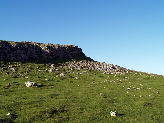 Crook Peak
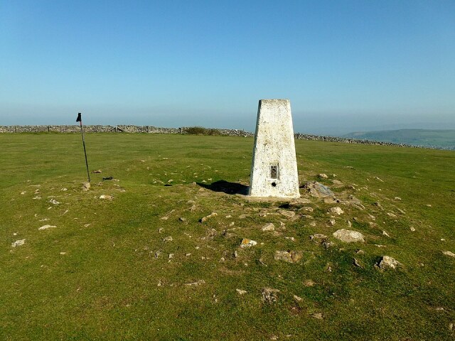 Trig point on Wavering Down
You follow the West Mendip Way east along the spine of the hills. This broad, grassy track makes for excellent walking, with good views to the right over Somerset, and to the left, beyond the boundary wall, over the county of Avon. Skylarks, linnets and meadow pipits can be heard and seen along the way.
The highest point of the walk is Wavering Down, where there are fine views south and east to the Poldens. Glastonbury Tor and the man-made lake of Cheddar Reservoir. From here you descend past the isolated stone and tile buildings of Hill Farm, found to the edge of King's Wood, designated a Site of Special Scientific Interest.
Some of this broadleaved woodland dates to before the Norman Conquest. Small-leaved limes are found here and great swathes of bluebells, ramsons and wood anemones appear in the springtime. There are many wood ant hills, and the insects provide food for green woodpeckers, whose drumming echoes through the trees.
On the other side of the busy A38 is another woodland nature reserve, which can be visited if you are willing to scramble up the bank through the undergrowth. The walk, though, takes you alongside the A371 to the National Trust land of Shute Shelve Hill, and runs between disused stone quarries to the town of Axbridge.
You cross to bypass, which follows the course of the old railway branch between Axbridge and Cheddar, into a high walled ancient alleyway. This takes you between gardens to Axbridge parish church, which is dedicated appropriately to John the Baptist, patron saint of clothiers. The exterior, in local grey limestone, is decorated with a profusion of pinnacles and gargoyles.
The interior, lit by large 15th century windows with grisaille glass, is spacious and well cared for. There is a handsome painted plaster ceiling in the nave, and the north and south aisle chapels contain monuments from the 17th and 18th centuries, dedicated to members of the Prowse family, and showing Restoration exuberance or Classical simplicity according to date. There is also a good 15th century brass on the north aisle wall. From the South porch, a flight of steps leads into The Square, where the walk began.
Acknowledgments: Text derived from the Out and Out Series; Discovering the Countryside on Foot. Pictures courtesy of Wikipedia.
Feedback and Suggestions: To suggest a link for inclusion on a this page please complete the Walking Englishman Feedback Form. Thank you.


