Portland Bill Peninsula Coastal Walk
A walk exploring the quarries and coastline of the Isle of Portland
Google Maps Open Source Maps| Statistics and Files | ||
|---|---|---|
| Start: Portland Bill | Distance: 6.9 miles (11.2 km) | Climbing: 211 metres |
| Grid Ref: SY 67769 68423 | Time: 3 hours | Rating: Moderate |
| GPX Route File | Google Earth File | Portland Bill |
| Statistics | |
|---|---|
| Start: Portland Bill | Distance: 6.9 miles (11.2 km) |
| Climbing: 211 metres | Grid Ref: SY 67769 68423 |
| Time: 3 hours | Rating: Moderate |
| GPX Route File | Google Earth File |
Ordnance Survey Explorer Map (1:25,000)
The Walk:
The Isle of Portland is attached to the mainland by the shingle bank of Chesil Beach and a narrow causeway. The natural shelter of the beach was enhanced by great breakwaters, and a military dockyard was built on the northern shore. Before this, the island was best known for its limestone, used in some of Britain's finest buildings. Stone appears everywhere. Great slabs of it sit like building blocks in a giant's nursery, and small, irregular boulders are piled up to make dry-stone walls in the sunshine. The stone shines a brilliant white.
This walk explores the southern half of the island and begins near the Bill of Portland at the southern end. The route heads straight for the Portland Bill Lighthouse, a dashing affair with bold red and white hoops.Built in 1906, the lighthouse replaced an earlier one that dated from 1789.
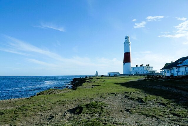 Portland Bill Lighthouse
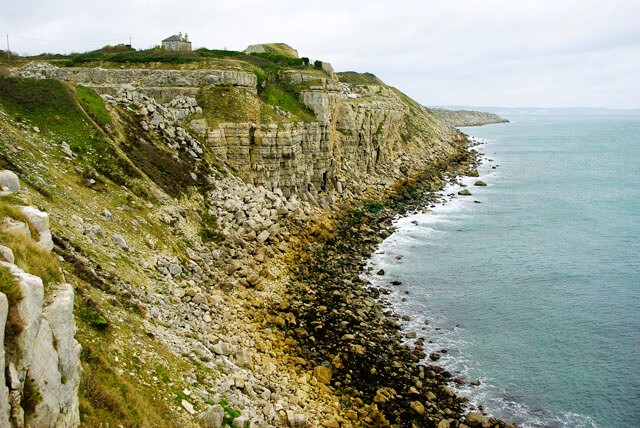 The cliffs of Freshwater Bay
On Portland Lighthouse is a plaque from the original, declaring that it was built 'For the Direction and Comfort of Navigators'. The 18th-century lighthouse was the first to use lenses to concentrate the beams. One reason why the light was needed can be seen out to sea. A tidal rip creates an area of rough water and white-capped waves, even on calm days.
The low cliffs extend out to sea as a series of flat ledges, the remains of quarries worked in the middle of the 19th century. The natural joints in the rock that made it possible to extract the stone in large blocks are clearly visible. On one ledge is a hand crane; cranes like this one loaded stone into sailing barges, but they are now used for raising and lowering small fishing boats. The area of the Bill has a large number of wooden huts and chalets, and a few huts are still used by the fishermen. Behind them is a row of former coastguard cottages.
The sea has eaten away at the rock ledges, leaving isolated stacks along the waves. A second lighthouse can be seen, and the top of a third beyond it. These two towers were built in 1716 and originally had coal fired lights. The nearer one is used as a bird observatory.
There is no shortage of bird life to watch as you walk along the clifftop; cormorants fish off the rocks and skylarks hover and sing above the grassland. On the high land at the centre of the island, a pattern of fields unchanged since the Middle Ages is visible. Huge Fields were divided by banks and walls, known as lawnsheds, into strips or lawns.
At Cave Hole there is a large circular depression where a cave roof has collapsed. At the bottom are a number of stone blocks around which the crashing waves come swirling in. The view begins to open out across Weymouth Bay, which is lined by undulating chalk cliffs. The path enters an area of old quarry workings, a fantastic landscape of piled stones and man-made ravines.
A small promontory runs out towards the cliff edge, on top of which is a double line of pierced stone blocks. The holes, plugged with wood, held spikes that fixed a railed track in place. Trucks of spoil were trundled along this crude railway and tipped over the cliff.
While the cliffs fall sheer to the sea, the walk bears left to a road. Away to the left is a rusted portable steam engine, once used in the quarries but long since abandoned. Nearer the road is a working quarry which produces stone aggregate. Beyond it is a superb example of a strip field system. The fields of this one small island were once divided by some 2,700 strips.
A path leads down from the road to the stony beach at Church Ope Cove, the favourite bathing place in Portland, then climbs steeply back up the cliffs to a little area packed with interest. From the top of the steps, you can look out to The Weares, a tumbled wilderness of rock above which the Portland railway once ran.
You go through an arch that was part of Rufus Castle. Begun by William II in the 11th century, it was largely rebuilt 100 years later.
 The Bill of Portland as viewed from Mutton Cove
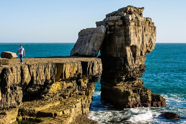 Pulpit Rock on the tip of Portland Bill
At the end of the 18th century, the castle and surrounding land was given to John Penn, whose father William founded Pennsylvania. He built a splendid mock fortress, Pennsylvania Castle at the top of the cliffs, and this is now a hotel.
The path from Church Ope emerges close to an excellent little museum that tells the story of Portland. The route heads along the broad main street of Easton, bordered by houses of local stone, and crosses the line of the old Portland railway, sunk in the deep cutting. A castellated house on the left boasts an extraordinary garden wall, made entirely of fossils, which range from curly ammonites to petrified wood.
The village square is graced by an unusually ornate Methodist Church, with a Wesleyan school of 1878 alongside it. From the square, the unusually named Reforne, probably a corruption of 'Reeve's horn' leads to the splendid Georgian Church of St George, which was designed and built by a Portlander, Thomas Gilbert, whose grandfather was a quarry agent for Sir Christopher Wren. A new house was built at the same time for the parish clerk. This later became the George Inn, and is used for meetings of the Court Leet.
Leaving the town streets behind, the walk continues on a footpath through one of the most interesting of the old quarries. At the bottom are traces of what was once the most important transport system on Portland. Rows of stone sleeper blocks show where a simple horse-drawn railway once ran.
The blocks lead out of the quality onto a broad track along the cliffs. This was the Merchant's Railway, built in 1826. A multitude of little branches joined the main line from all the quarries along the route.
Today the track bed makes an ideal footpath. The view is magnificent. Chesil Beach, once the only route between Portland and the mainland, stretches away into the far distance. To its east are the breakwaters that create the still waters of the naval base, above which helicopters hover and buzz.
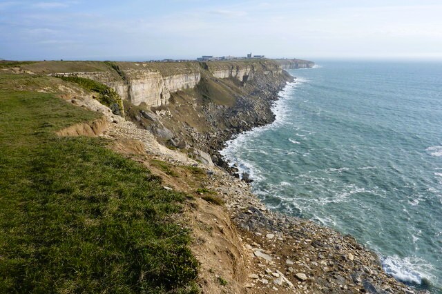
The cliffs on the western side of the island are higher and more dramatic than those on the east. Those who want to pause, to drink in the views, can stop at a rather grand seat, made of huge chunks of stone.
All the way along this section of the walk are reminders of the old quarrymen. A track used for tipping spoil runs over an arch built up of huge squared-off blocks. Beyond the arch, the path narrows and becomes stonier. Grooves in the rock mark the line of the old railway.
You emerge on grassland above the cliffs and head inland past the Ministry of Defence area. The old lighthouse, a stumpy little tower with what looks like a summer house on top, comes into view. This was once the home of Dr. Marie Stopes, the birth control pioneer.
Finally you head towards Pulpit Rock, a sea stack, which until a century ago was a rocky archway. It has a slab leaning against has footholds to provide a stony ladder for the adventurous to climb.
Acknowledgments: Text derived from the Out and Out Series; Discovering the Countryside on Foot. Pictures courtesy of Wikipedia.
Feedback and Suggestions: To suggest a link for inclusion on a this page please complete the Walking Englishman Feedback Form. Thank you.


