Ludlow, Mary Knoll Valley and Overton
A Perfect Historic Town - From a town rich in architectural history to explore hills and valleys
Google Maps Open Source Maps| Statistics and Files | ||
|---|---|---|
| Start: Ludlow Station | Distance: 7.9 miles (12.8 km) | Climbing: 373 metres |
| Grid Ref: SO 51330 74994 | Time: 3-4 hours | Rating: Moderate |
| GPX Route File | Google Earth File | About Ludlow |
| Statistics | |
|---|---|
| Start: Ludlow Station | Distance: 7.9 miles (12.8 km) |
| Climbing: 373 metres | Grid Ref: SO 51330 74994 |
| Time: 3-4 hours | Rating: Moderate |
| GPX Route File | Google Earth File |
Ordnance Survey Explorer Map (1:25,000)
The Walk: Ludlow has often been described as the perfect historic town, which is not surprising once you become familiar with its treasures. Sitting astride a limestone outcrop, defended on three sides by the Rivers Teme and Corve, is a Norman castle, accompanied by its walled town. Streets, planned many centuries ago, are laid out in a rectangular grid in which is found a wealth of medieval, Tudor and Georgian architecture, including 469 listed buildings. The old name for the town was Ludelaue, meaning 'loud hill' or 'the hill by the loud waters', for then there were rapids rather than weirs in the river.
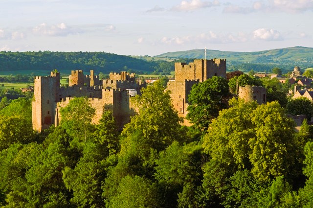 Ludlow Castle
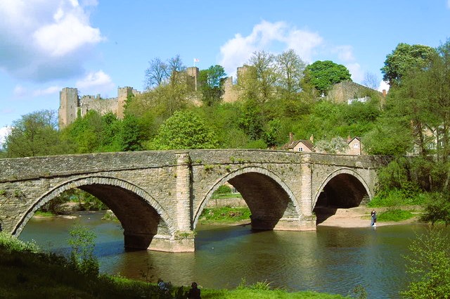 Dinham Bridge spanning the River Teme
The walk begins by touring part of the town. It then goes out into the Mortimer Forest to visit features of the limestone anticline, or fold, responsible for the natural defences of the town. On the return, there are panoramic views of these hills. Finally, the walk visits some more of Ludlow's ancient treasures.
The formation of Ludlow's environment began some 420 milion years ago, when the sediments that formed the surrounding limestones and shales were first laid down on a prehistoric sea bed. Corals, bivalve shells, early fish and shrimp like creatures were trapped at this stage and their fossilised remains can be found today. The rocks were folded up as land masses moved.
The anticline that this formed is seen today as a high and wide range of hills that slope down and taper to a rounded point. The tip of this point has now been isolated from the remainder of the River Teme. This rocky outcrop supports the town and, across the river, to the south-west, the hills rise behind Whitcliffe. These natural defences were a perfect site for a castle when the Norman invaders needed to secure the borders with Wales.
As time advanced and needs changed, the castle expanded into a walled town, growing wealthy on the wool and cloth produced in the area. Many highly ornate timber framed buildings resulted from this early prosperity. Farm produce and the towns role as an administrative centre for Wales and the Marches ensured continued wealth. In Georgian times Ludlow even became a fashionable resort.
Industry using the waters of the River Teme and the River Corve gave the town a sound financial base in the 19th century. However, improved communications and the demise of its industries led to an exodus of the rich. There was little new development, and the town retained its architectural magnificent, unsullied by Victorian improvements.
The first of the magnificent buildings encountered on the walk is the Feathers Hotel. An earlier building was enlarged in 1619 and the following year it was opened as a hotel. It is one of the best known of all half timbered buildings, with its beautifully carved exterior and equally impressive interior.
The walk crosses to the courtyard of the Bull Hotel, no longer echoing to horses hooves and iron rimmed wheels, and climbs the steps to the churchyard. The Reader's House on the left is a medieval house that was rebuilt in 1555 with the porch added in 1616. St Lawrence's church was rebuilt from 1433 to 1471, but stands on original 12th century foundations. The Hoyser's Almshouses were rebuilt in 1758. The Butter Cross is of a smilar period (1743-6) but Bodenham's dates back to the early 15th century, when overlapping upper floors gave more space without encroaching upon the crowded streets below.
Moving on towards the Market Square, look for Harp Passage with its cobbled paving, central gutter and overhanging upper storeys, giving the feel of a medieval street.
At the gate of Ludlow Castle, you can either go in and see the views from the tower, or turn right and go around below the ramparts. The path drops down to Dinham Bridge. The present structure replaced a medieval bridge in 1823.
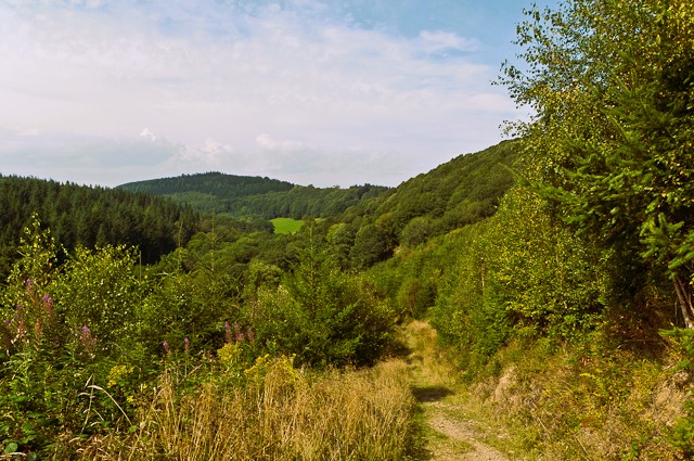 Mary Knoll Valley
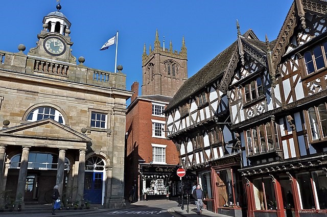 Grand buildings of Ludlow
The route now moves on to the woodlands of Mortimer Forest. Incidentally, the name will not be found on any map as it is a collective name chosen by the Forestry Commission to cover many woodlands around in the vicinity. The walk climbs a steady gradient up above Whitcliffe, against the tilt of the folded anticline. The forest is a mix of broad leaved and coniferous trees, mainly oak and ash, with some planted beech alongside Douglas fir, larch, sitka spruce and Scots Pine. A herd of unique long haired fallow dear lives here, and you may spot them if you are unobtrusive.
At Mary Knoll House, the path begins the descent into Mary Knoll Valley. This deep, steep-sided valley was formed by a fault across the anticline, caused by untold stresses during the folding of the rock. Erosion of a ready-made line of drainage has accentuated the feature. Bare rock faces may be worth examining for fossils.
The return walk includes visiting the tiny village of Overton before crossing farmland and following the B4361 Overton Road to arrive at Ludford Bridge, built in the 14th century. Rather than cross the bridge, you turn left up the Wigmore Road to gain a footpath over Whitcliffe. This affords one of the best known views in Shropshire, looking across the River Teme to Ludlow Castle and the ancient town. The walk then descends to Dinham Bridge and crosses it to St Thomas's Chapel, built around 1180.
Further on, at Mill Gate, there are good views of the town wall. Notice Palmer's Hall, belonging to Ludlow College. It used to be a medieval Great House. The walk climbs Mill Street to turn right into Bell Lane and through to Broad Street. Downhill is the 13th century Broad Gate, capped by a 16th and 17th century house. As you walk up Broad Street to the town centre, there are several houses with blue plaques.
This tour of the town is merely a taste to wet the appetite. Guidebooks and guided tours are available if you wish to know more about this 'perfect historic town'.
Acknowledgment: Text derived from the Out and Out Series; Discovering the Countryside on Foot. Pictures courtesy of Wikipedia.


