Walks in Sheffield and the Surrounding Area
Sheffield is famous for walking. It was a ramblers group from Sheffield who along with their Manchester counterparts organised the infamous trespass onto Kinder Scout, the civil action which was instrumental in ordinary people gaining access to the moors and mountains of Great Britain. Since then more and more of Sheffield folk have enjoyed the freedom of walking in their city and surrounding area which holds many natural treasures. On the southern and western fringes of Sheffield there are marvellous Peak District walks to be enjoyed. The theme here is stunning gritstone edges, heather moors, sumptuous valleys and reservoirs. To the north walks are enjoyed to woodland, upland trails, parks and to lovely towns and villages. Venture into the city and to east and south for industrial trails, parks, gardens and landscaped estates. There are also a number of long distance paths and feature trails in and around the city. I visit Sheffield often, to walk and to see family who live in the Walkey area. So keep looking in. New walks will frequently be added to this library of my favourite Sheffield walks.
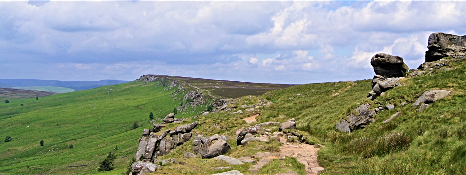
Stanage Edge, one of the popular granite outcrops on the outskirts of Sheffield
Interactive map of the walks
| Walk | Miles | Description |
|---|---|---|
| Sheffield City Industrial Heritage Trail | 1.7 | A fascinating walk of Sheffield's industrial past which visits the sites of some of the oldest works in the city. |
| Low Bradfield, Agden Side, Rocher Edge and High Bradfield | 4.3 | A lovely half day walk on the outskirts of Sheffield. There is much to enjoy on this very popular route. |
| Higger Tor and Padley Gorge | 5.5 | A wonderful contrast of heather moor in late summer bloom and an oak wooded gorge are to enjoy here. |
| Thorncliffe Trail | 5.5 | On the edge of the Peak District exploring history in an interesting part of north Sheffield. |
| Rivelin Valley Nature Reserves and Heritage | 6.2 | A linear walk of the Sheffield's historic Rivelin Valley from Redmires Reservoir to Rivelin Park. |
| Stanage Edge from Hathersage | 6.5 | The iconic dark peak walk to the most famous millstone grit escarpment of them all. |
| Grenoside, Greno Wood, Wharncliffe Wood and Whalejaw Hill | 7.2 | A lovely woodland themed walk north of Sheffield, full of natural beauty and steeped in historic interest. |
| Wentworth Woodhouse, Nether Haugh, Hoober and Elsecar Heritage Village | 8.0 | A Stately Home, Follies, Monuments, Ancient Woodlands and South Yorkshire's premier industrial heritage site. This walk has them all. |
| Ladybower Reservoir, Alport Castles and Ashop Dale | 9.0 | A lovely walk in the Dark Peak from Ladybower Reservoir to the outstanding Alport Castle landslip formations. |
| Redmires Reservoir, Stanage Edge and Hallam Moors | 9.3 | A wonderful walk to the west of Sheffield which also includes Stanage Pole, High Neb and Hollow Meadows. |
| Ladybower and Derwent Edge | 10.5 | A walk of contrast, a reservoir walk and then a moorland crossing followed by an exploration of Derwent Edge. |
| Derwent and Howden Reservoirs, Margery Hill and Howden Edge | 11.2 | A Dark Peak walk to desolate and beautiful south Pennine moors which begins in the Upper Derwent valley. |
| Sheffield Country Walk | 53.0 | Stephen Tozer-Loft's walk around the outskirts of the city with many sites and buildings of archaeological, historical and industrial interest visited. |
Feedback and Suggestions:
I am always pleased to received feedback on the structure and content of the website. I also welcome suggestions on how I can improve the website which may include new areas to cover, new walks or route alterations to existing walks. To get in touch with feedback and/ or suggestions please contact me on one of my social media links. Thank you.
(Note: Walking without proper preparation can be dangerous. Information and downloads on this website are provided free of charge; it is each walker's responsibility to check the material and use accordingly. Postscript: My walk reports are not route guides and should not be treated as such. They are written with personal reflections of my walks)


