South Downs Way
A personal record of my walk of the South Downs Way National Trail with a written journal and with photographs. Tracklogs for GPS units and for use with Google Earth are available for download for each stage.
Journal, Photographs and Download Files
Stage 1: Eastbourne to Alciston
Google Maps Open Source Maps| Statistics and Files | ||
|---|---|---|
| Start: Eastbourne | Finish: Alciston | Distance: 17.1 miles (27.5 km) |
| Time: 7-9 hours | Climbing: 892 metres | Rating: Hard |
| GPX Route File | Google Earth File | South Downs Way Guide |
| Statistics | |
|---|---|
| Start: Eastbourne | Finish: Alciston |
| Distance: 17.1 miles (27.5 km) | Time: 7-9 hours |
| Climbing: 892 metres | Rating: Hard |
| GPX Route File | Google Earth File |
Ordnance Survey Explorer Map (1:25,000)
OL10 Arundel, Pulborough, Worthing and Bognor Regis
OL11 Brighton and Hove, Lewes and Burgess Hill
OL25 Eastbourne, Beachy Head, Newhaven, Seaford, Hailsham and Heathfield
The Walk:
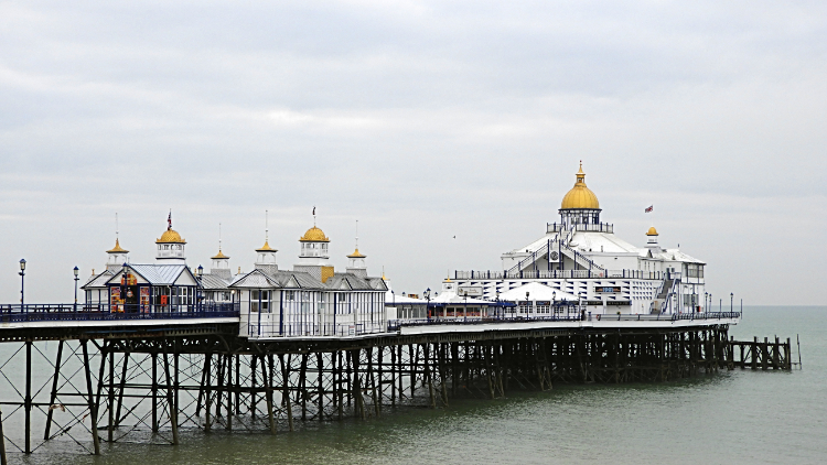 Eastbourne Pier
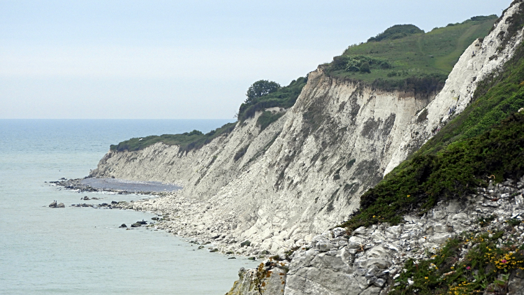 Chalk cliffs at Holywell Ledge
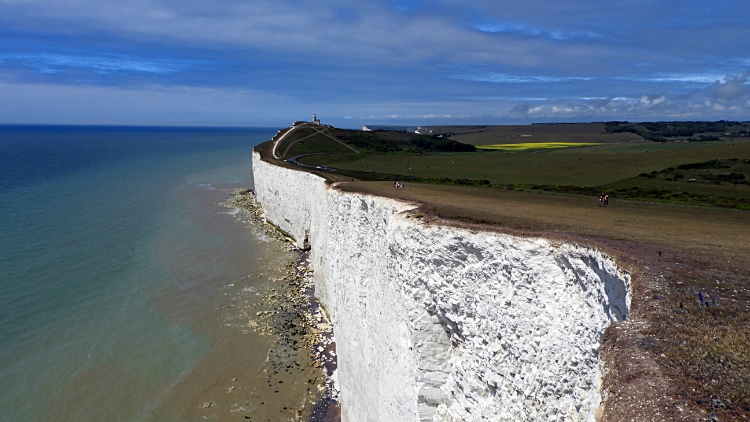
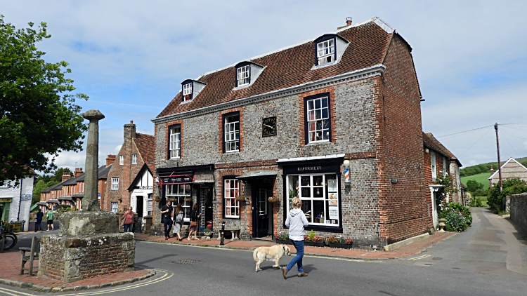
I set off from the pier in Eastbourne full of excitement. While a little miffed at the unheralded sight of morning cloud drifting in from the sea I was hopeful it would fade away by the time I got out of town. This walk had been a long time in the planning and I had plumped for what the met office said was a good week of settled weather. So it had better be right. "Cloud, go away. Please. I want to enjoy Beachy Head and the Seven Sisters in sunshine". I had never seen them before and I so wanted to enjoy the famous white cliffs at the shimmering best. The cloud persisted as I walked south west along Eastbourne seafront to Meads. It had been a minute before six in the morning when I had set off walking and it was 6.45am when I reached the suburb of Meads. "Time for breakfast" I thought and having not found a cafe open on the seafront parade I headed down Holywell Road and Meads Street to find one open. Black Cat Tearooms did me proud. An hour later, at 7.30am and back on the coast, I dropped down to the shore at Holywell Edge and enjoyed my first view of the famous white cliffs. The sun was hidden but the view of the white chalk cliffs of Holywell Ledge were a tremendous prelude to what was to come.
 Beachy Head
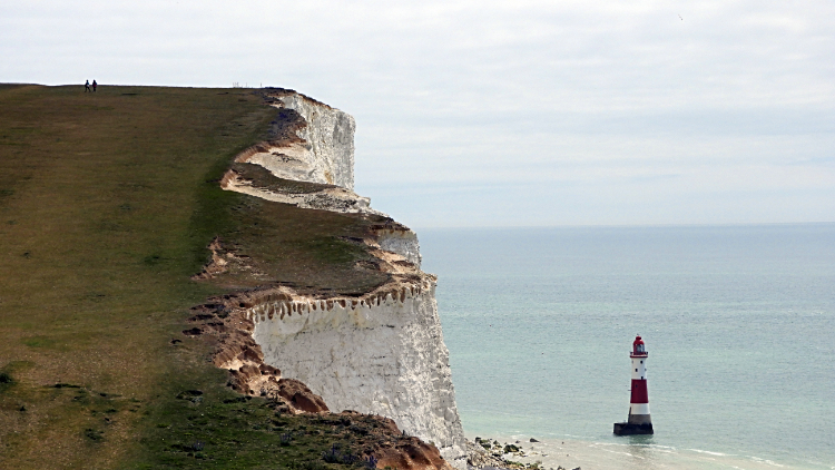 View back to Beachy Head from Shooters Bottom
I left the coast and climbed to the end of King Edwards Parade/ Duke Drive where an information board officially welcomed me to the South Downs Way National Trail. 'Eastbourne - Winchester 100 miles' it said and it highlighted five places between. Ditchling Beacon, Devil's Dyke, The River Arun, Harting Down and Butser Hill. I looked forward to all five and much more besides. But first was my walk along this immediate and historic section of coastline. Two routes were offered to me at the information board. Left and along the coastline path to Cow Gap and Beachy Head or right to Jevington. No contest, I had always planned to go left. Up to Cow Gap I went, following not just the South Downs Way but also the Wealdway. At Cow Gap and looking out to sea I watched a flotilla of small boats heading along the channel from east to west. There were around fifteen boats, all identical and all carrying French flags. I could not make out what the significance of their actions at the time but it would some become obvious to me. I will come to that later. For now I crossed the heathland north of Beachy Head to reach the RAF Bomber Command Memorial. Here I stopped for thirty minutes, part in tribute to the heroes of World War Two and part in anticipation of a sunny walk along the coast. Cloud was sweeping across the site from west to east and momentary gaps in the cloud allowed the sun to show. As time went on the gaps in the cloud became greater. The sun was coming out to play. Heartened and warmed by its appearance I resumed my walk to Beachy Head. On the way I passed the memorial to PC Harry Ward, a memorial to five French WW2 soldiers from Picardie, a memorial to the Allied Forces including the Women's Auxiliary and the Home Guard and a memorial signal station. There was a heavy sense of respect, memory and loss up here which I really got. I took a minute at the site of the signal station to show my appreciation.
 White Cliffs and Belle Tout
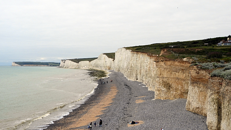 The Seven Sisters
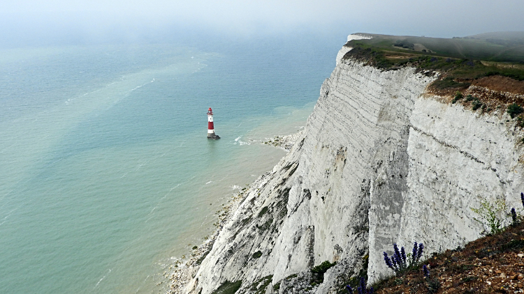
The next three hours of my walk from Beachy Head to Cliff End near Cuckmere Haven were such a delight. While some cloud still persisted in the channel it was breaking up inland and providing instant warmth. It was the last day of May after all and the sun was almost as strong as can be in this most southerly location of the east half of the UK. All of a sudden I noticed people around. There had been none before but now cars were filling the car parking areas at Beachy Head and at Shooters Bottom. Individuals, couples and family groups were strolling on the cliff tops. At Beachy Head I passed a group of film makers. "Was I in the shot?". The chalk cliff of Beachy Head was naturally a highlight, the huge 162 meter high cliff made up of parallel lines of chalk segregated by narrow black lines about every half-meter. I tried to work out how many there were. I counted fifty or so down and gave up as they merged into blur. The lighthouse set in the sea at the bottom of the cliff was an appealing sight too. Rollicking down to Shooter's Bottom was fun. I was in rapture and from there the climb to Belle Tout Lighthouse was great fun too. From the site of the lighthouse, now a private residence I ambled on to Birling Gap where I stopped for a coffee break. I was in no hurry at all.
While at Birling Gap I took the opportunity to walk down to the shore and look at the Seven Sisters. I tried to make them all out individually but found I was getting stuck at six. Was one of them hiding around Cuckmere Haven? Six? seven? Whatever. It was a beautiful sight all the same. I was so pleased to be looking at it at last. Stunning. After my viewing and after my coffee I headed on the roller coaster walk that is the near two mile stretch of the South Downs Way atop the Seven Sisters. Here we go: up to Went Hill, down to Michel Dean, up to Baily's Hill, down to Flathill Bottom, up to Flat Hill, down to Flagstaff Bottom, up to Flagstaff Point, down to Gap Bottom, up to Brass Point, down to Rough Bottom, up to Rough Brow, down to Limekiln Bottom, up to Short Brow, down to Short Bottom and up to Haven Brow. Phew, all done. It was a relief to reach Cliff End where I was granted a great view of Cuckmere Haven. Fittingly, as I paused to look out at the view a Spitfire airplane flew right over my head. Why was it appropriate? as with the flotilla of boats I will come to that in a while. For now it was time to make my leave of the coast and in that I was a little sad. I reconciled myself with "What delights are next in store?".
 Cuckmere River
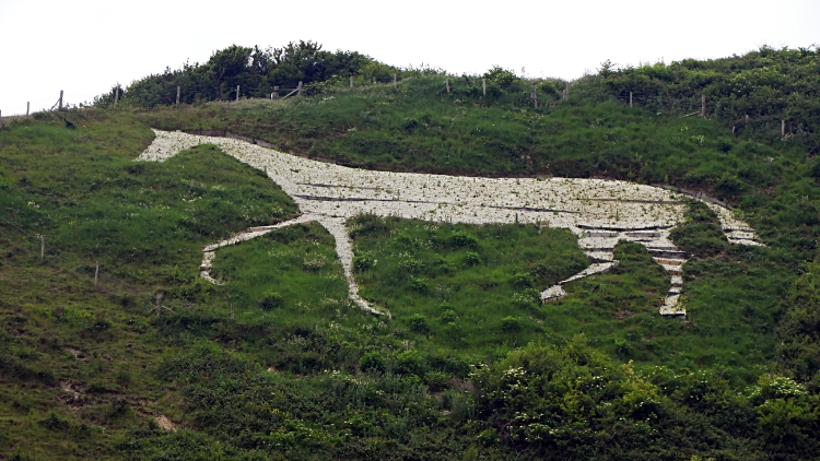 Litlington White Horse
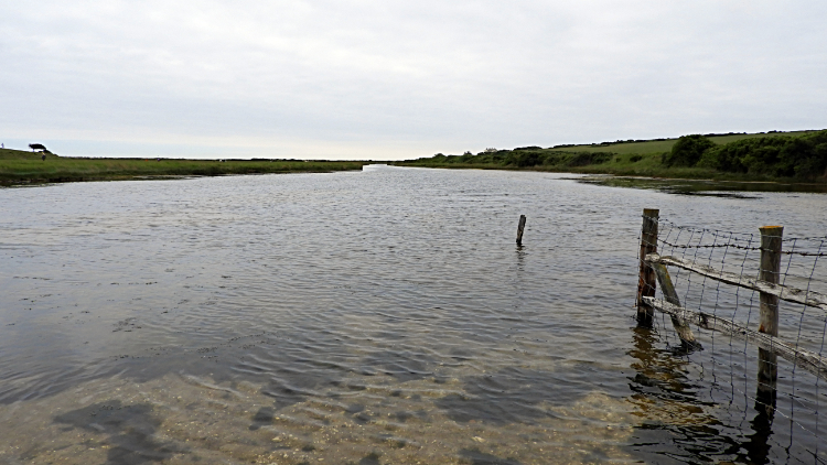
There were lots of people down on the sands of Cuckmere Haven and there were more groups of people heading towards me from inland on the South Downs Way. It was busy here. At just before the point where I crossed a footbridge over the River Cuckmere I passed a group of around sixty youngsters. That was a lot. Then once over the river I was by myself again. For three hours I had been near people all the time, a consequence of walking in a beauty spot, but suddenly I was alone again. And I liked it. In solitude I find I can appreciate the natural surroundings much better and when solo I can spot things I would not do when in company. And lo and behold, I looked across a flood plain next to the river and stood stock still while watching a female Shelduck with eight fluffy black and white chicks paddling across the water. I would most likely have missed that wonderful moment had i been passing people or with a walking group. For nature, alone is best. staying with the river I reached Exceat Bridge and crossed the A259 road to continue along the river to see the Litlington White Horse. Not as ancient as some, this one is a local attraction and the present incarnation created in 1924. Still it was an attraction I had to see. In doing so I ran the gauntlet of a herd of cows with calves but they had little concern in me so long as I quietly walked on by.
 Alfriston
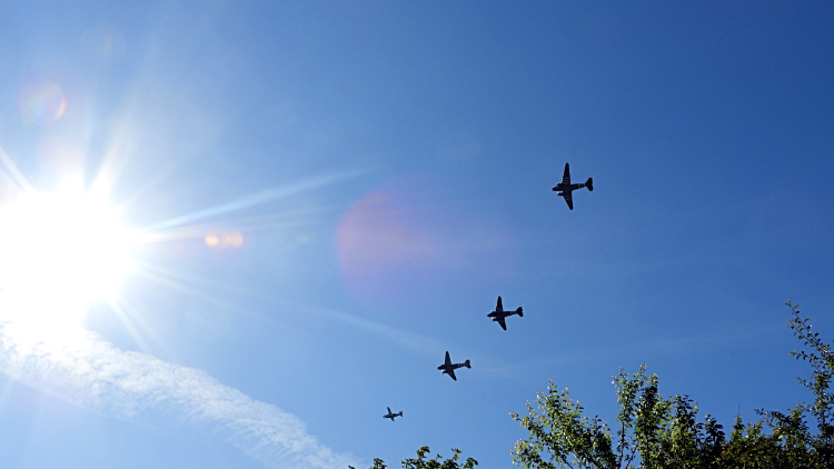 D-Day 75th Anniversary Squadron
From Litlington White Horse I enjoyed a delightful riverside walk to Alfriston. The fields and meadows of the river plain were lush with grasses and the paths good to walk. Gates, stiles and footbridges were all well maintained but not turned into modern conveniences. They retained their old wordy character which made the whole of the walk in the river valley much more appealing. Eventually I came to the end of my valley walk by arriving in Alfriston. The village was absolutely gorgeous with houses and shops so characterful. Locals and day trippers were milling about in the village. Nobody at all in a particular hurry. Except me that is. I needed an afternoon tea and I still had quite a few miles to go. It was uphill from Alfriston, to my first adventure with the South Downs and I fancied tea and cake to set me up. Scrumptious it was, I did enjoy it so. As did the two Sparrows who shared my cake with me. After the energy boost I topped up with supplies at the local olde worlde shop and set off on my way from the prettiest of villages to the first heights of my South Downs walk. Not that high at only around 180 meters but I was climbing from sea level. I climbed through the higher streets of Alfriston on the path towards Long Burgh Long Barrow. As I did so, and in the shield of a tree lined avenue, I heard this hum which became a roar and then all of a sudden the sky above me was filled with aircraft. A chevron of six aircraft passed over while I rushed to get out my camera. I got the four in picture. And then it twigged. "The flotilla of small boats, the Spitfire, and now this small Squadron of World War Two aircraft. The 75th anniversary celebration of D-Day!". I had forgotten all about it in the excitement of my first day on the South Downs Way National Trail walk but now it was fixed in mind. Would I see more? With that thought I continued climbing, passing Long Burgh Long Barrow and reaching the top of the South Downs.
 South Downs near Alfriston
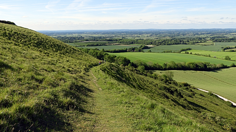 Descending to Alciston
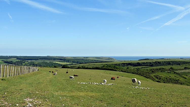
The views opened out and on the south side for miles around. All down to the coast and to the line of the English Channel which was a marvellous sight. I strolled towards Bostal Hill as I did not have long on my first walk up top, soon to drop down to my accommodation at the Rose Cottage Inn, Alciston. Just before reaching the point where I had to descend I saw two ladies walking from the north, across a field and towards me. When they got to me one of them asked "Did you see them. The planes?". Telling them I did we talked about the D-Day event coming up on the 6th May and how lots of veterans, army groups, politicians and military craft were assembling in preparation for them. And then as we were speaking my eyes opened wide, I gaped and I nearly collapsed in awe. I was facing what was coming and the ladies had their backs to it. "Turn around ladies. Quick. There are more coming right over our heads!". Suddenly we had a dozen or so American Aircraft in formation flying right over our heads. I broke from our ecstasy and photographed Douglas DC - N24320 and others besides. It was an awesome five minutes with the ladies as the fly past occurred. We felt so privileged. Bidding them goodbye I continued on my way and descended from the downs to reach Alciston and my accommodation for the night. My first day was complete on the South Downs Way and was in rapture. I slept well.
From my evening Facebook Post "Day one done, 15 miles of lovely walking. The first half was along the coast with the gorgeous white cliffs my companions. The Seven Sisters were an up, down, up, down, etc rollercoaster. Nothing too demanding but nothing level either. Then I cut inland to Alfriston, much of it following Cuckmere River and passing the High and Over White Horse. Finally a climb to the downs was followed by a descent to my accommodation in Alciston. Two remarkable events of note along the way. First were the military fly pasts by aircraft most probably massing in the area for the D-Day 75th anniversary celebrations next week. There were about 20 in all, in formations of 3 to 5. Next was meeting two ladies on the trail who took me out to the local pub for a drink afterwards. Marvelous hospitality! Tomorrow just a wee 20 miler."


