Holy Island
An exploration of Lindisfarne, complete with fishing village, castle and priory ruins
Google Maps Open Source Maps| Statistics and Files | ||
|---|---|---|
| Start: Village Centre | Distance: 3.4 miles (5.5 km) | Climbing: 40 metres |
| Grid Ref: NU126420 | Time: 2 hours | Rating: Easy |
| GPX Route File | Google Earth File | About Lindisfarne |
| Statistics | |
|---|---|
| Start: Village Centre | Distance: 3.4 miles (5.5 km) |
| Climbing: 40 metres | Grid Ref: NU126420 |
| Time: 2 hours | Rating: Easy |
| GPX Route File | Google Earth File |
Ordnance Survey Explorer Map (1:25,000)
The Walk: Part of the attraction and adventure of visiting Holy Island is that it is cut off from the rest of the world by the sea for much of the time. The mainland can only be reached at low tide. In the 7th century, monks found this an ideal location, leaving the island occasionally by crossing the sands when the sea had receded. Their route became known as the 'Pilgrim's Causeway' and, until recent times, it remained the only way across. It was improved by the positioning of poles to mark the route in 1860 and the provision of refuge huts on stilts for anyone caught out by the swift inrush of the tide. But it was not until 1954 that a metalled road was opened; and this was extended and improved in 1965. Tide tables at each end of the causeway are still essential when planning a crossing.
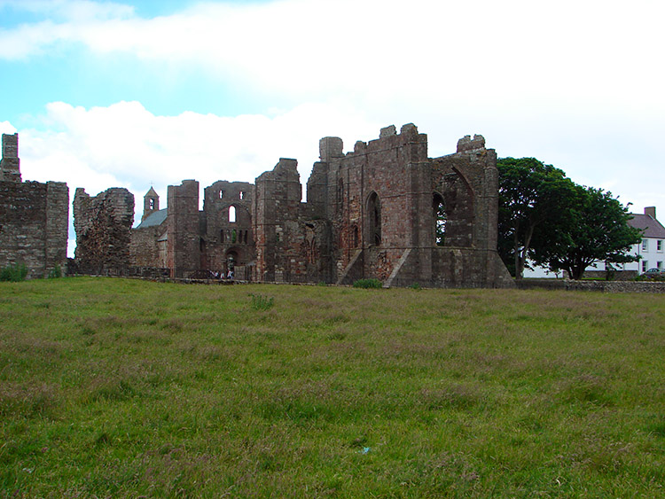 Lindisfarne Priory
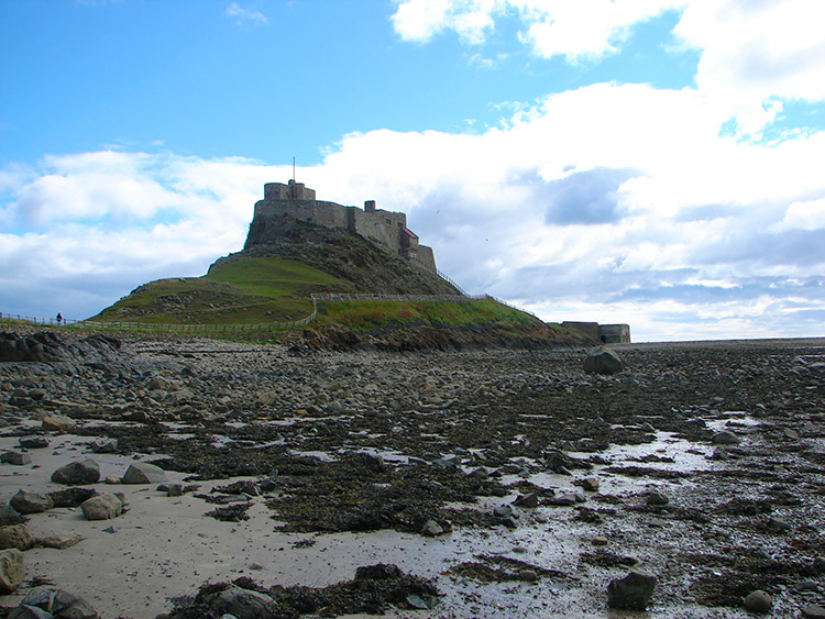 Lindisfarne Castle
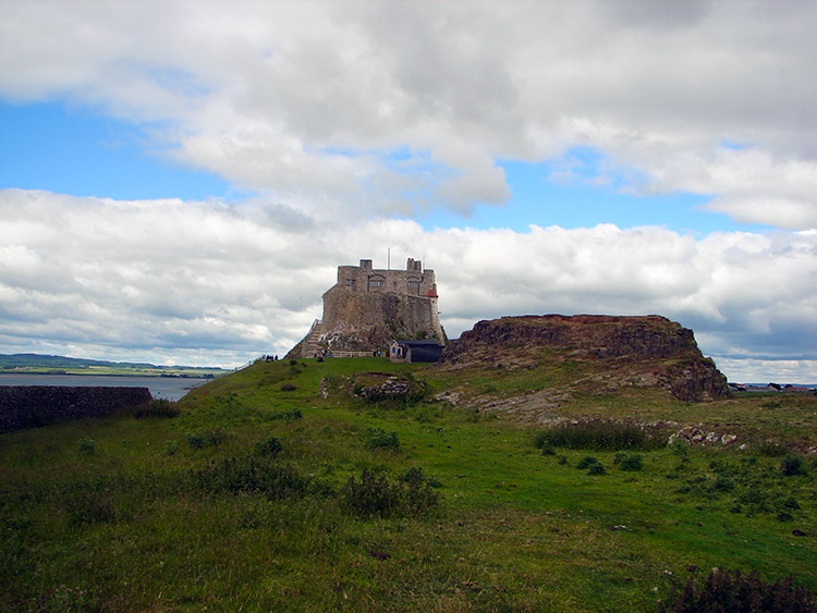
From the island's main car park, a short walk brings you into the village centre. Nowadays it caters mainly for visitors, but its heyday was in thr 19th century, when fishing and quarrying were the main occupations. Herring were cured and donkeys were used to carry panniers of fish across the sands to be sold by fishwives. Life was hard and rough for much of the time, but there were at least ten inns to provide some solace.
The museum, church and priory are at the south end of the village, beyond the square. In the priory grounds stands an impressive statue of St Aidan. In 635 AD, the Northumbrian King Oswald asked the monks of the Irish monastery on Iona to send missionaries to bring Christianity to his kingdom. They sent Aidan, who founded a simple wooden monastery on Holy Island, which was then called by its Celtic name, Lindisfarne. The castle and priory are still referred to with this Celtic name. Aidan and his companions spent much time travelling through the north, visiting the people in their huts among the hills. In Aidan's lifetime, the Chritian faith was firmly established in Northumbria.
Aidan's sixth successor was Cuthbert, a warm hearted and practical person according to accounts given to the father of English history, the Venerable Bede. Cuthbert became an early folk hero, revered by everyone. It was in honour of God and Saint Cuthbert that the Lindisfarne Gospels were produced by the mo0nks. These exquisite illustrated manuscripts are now in the British Museum.
The wooden monastery was burnt down in Viking raids, and the monks were forced to flee, taking the Gospels with them. But the monastery was rebuilt, in red sandstone, by Benedictine monks from Durham, who dedicated the building to Saint Cuthbert. The ruins of the monastery chiurch remain.The history of the island is described in a small museum, where there is a reconstruction of a monk's cell. Next to the priory ruin is St Mary's Church, which begun in Norman times.
 View from Castle Point
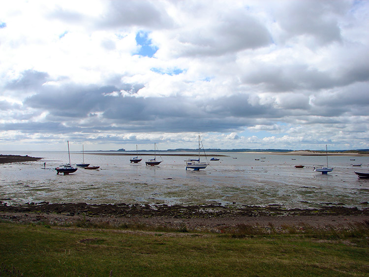 The Harbour on Holy Island
The path from the west gate of the church leads to a grassy shelf and a view of St Cuthbert's Island, which is joined to the mainland at low tide. Cuthbert spent whole days in prayer there, but eventually he chose an even more remote location, on the Farne Islands, further out at sea, now popular for spotting wildlife including seals and sea birds.
A stony path leads on to the Heugh, a hill created by an intrusion of hard volcanic rock. There are some fine views from the promontory. The route comes down the Heugh to the Ouse, a harbour sheltering fishing boats. Lobster pots line the jetty and there are upturned herring boats which serve as fishermen's stores.
There is a path leading from the harbour to Lindisfarne Castle. By Northumbrian standards the castle is modern (16th century) and small, having only twelve rooms. Its original purpose was to guard the harbour. The volcanic outcrop called Beblowe Hill, at the harbour entrance, was the obvious site for the castle. Its history is entirely peaceful; the only exception occured when two Jacobites took the castle, having discovered that there were only two people left in charge, out of a garrison of seven. They attempted to flee the next day, but were captured.
In later times the castle was restored by Sir Edwin Lutyens, to provide a desirable residence for Edward Hudson, proprietor of Country Life magazine. The caslte is now open to the public, in the stewardship of the National Trust. Inland from the castle there is a delightful walled garden among the bare fields. It was created by Gertrude Jekyll. The garden can be viewed over the gate and it is possible to look around when gardeners are present.
Beyond the castle are well preserved lime kilns which swallows and swifts fly around in the summer months. From the kilns the walk extends northwards to the Lough, a small pond and then west on a path for a short while before turning south on a path back to the car park.
Acknowledgments: Text derived from the Out and Out Series; Discovering the Countryside on Foot. Pictures courtesy of Wikipedia.


