Grassington, Conistone Pie, Conistone Dib, Grass Wood and Ghaistrill's Strid
Follow the Dales Way from Grassington to Conistone by limestone pavements, cliffs and gorge before returning via woodland and the River Wharfe
Google Maps Open Source Maps| Statistics and Files | ||
|---|---|---|
| Start: Grassington | Distance: 9.5 miles (15.2 km) | Climbing: 422 metres |
| Grid Ref: SE 00375 63829 | Time: 4 hours | Rating: Moderate |
| GPX Route File | Google Earth File | About Grassington |
| Statistics | |
|---|---|
| Start: Grassington | Distance: 9.5 miles (15.2 km) |
| Climbing: 422 metres | Grid Ref: SE 00375 63829 |
| Time: 4 hours | Rating: Moderate |
| GPX Route File | Google Earth File |
Ordnance Survey Explorer Map (1:25,000)
Summary: My walks usually have a highlight or two which is easy to describe, a spectacular mountain top or beautiful waterfall. This walk is different as it is so full of highlights that to single one or two out would be a disservice to the others. Even the headline description misses some out. From the start in Grassington, surely one of thew Yorkshire Dales finest village the walk follows the Dales Way footpath across spectacular limestone country where some of the best examples of limestone pavement can be seen. There are gorges, bluffs and inland cliffs to enjoy too, all before remarkable Conistone Pie is reached. All that in the first third of the walk. Conistone Dib, the village of Conistone, Dib Gorge, Far Gregory, Grass Wood, River Wharfe and Ghaistrill's Strid, all highlights in their own right follow. Plus a visit to a prehistoric hill fort. This walk is thrills galore.
The Walk:
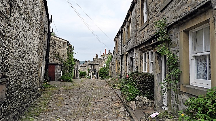 Grassington
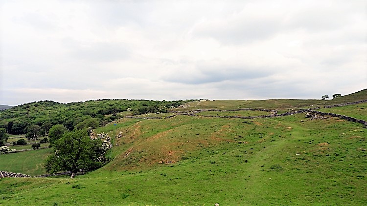 Medieval Grassington?
Setting off on a walk from Grassington always fills me with a sense of anticipation and I was delighted when I clicked the key to lock the car and walk my way through the delightful Wharfedale village. After making my way along eerily quiet Main Street of pretty shops and inviting inns which is always busy with people and positively heaving at weekends and on Bank Holidays I turned left to follow Chapel Street and then Bank Lane to reach open country. I followed the Dales Way across the site of the original Medieval settlement of Grassington. A series of enclosures and rectangular building platforms can apparently be made out in the pastures north of Town Head Farm. To me I identified the site as one of humps and hollows, probably the remains of the old village earthworks. This first part of open country was quite undulating.
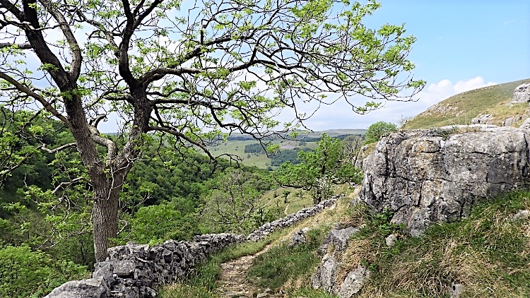
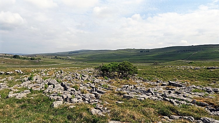 Limestone Pavement
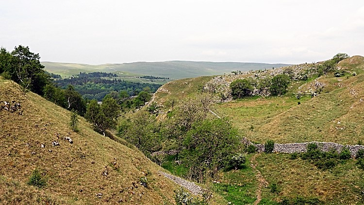 Dib Gorge
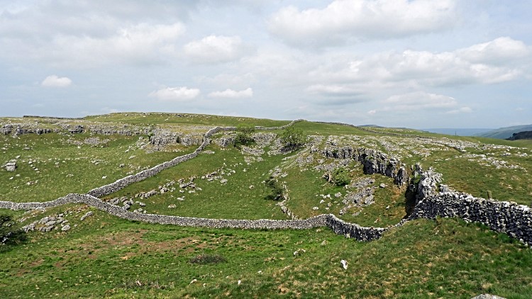
I left the Dales Way path and climbed from the site of the Medieval village to Lea Green and to the first sections of limestone pavement. I had now climbed 100 metres since setting off and just about levelling off on a plateau of upland, all around 300 metres above sea level. And yet here I am walking on a sea bed. At least the remains of one. It still astounds me to think that the limestone pavement I was now standing on was created under seas formed by deposits of sea life which themselves formed rocks. Once a setting of underwater beauty the pavements are now the setting of upland beauty. No less so, I absolutely adore being on limestone pavement where the shelter of clints and grykes allow a rich diversity of life to thrive. Rowan, Hawthorn and other hardy trees take root in the shelter of grykes and adorn the otherwise barren plateaus with copses and small areas of woodland. Plant life also does well in the shelter provided by the limestone including Ferns, Wood Sorrel, Dog's Mercury, Anemones, Yellow Rock Rose, herbaceous Thyme and even some rare Orchids. Take a close look at the wonderful array of plants below you in the gaps next time you cross a limestone pavement. I wandered across the limestone pavements of Lea Green looking down into the voids as much as I looked up across the gorgeous land, hopping and playfully skipping too, all until I reached Dib Gorge when my attention was forced to focus on keeping my feet on the steep descent down.
 Old Pasture
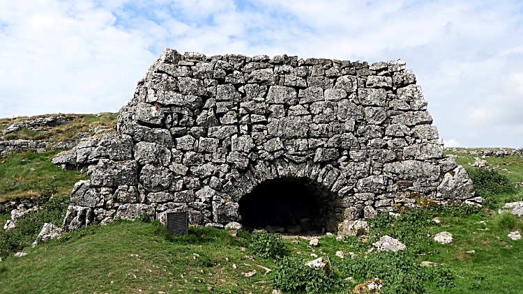 Lime Kiln on the Dales Way
Twenty five metres down and then 50 metres up took me clear of Dib Gorge which I did so by following the gorge up to return to the Dales Way path. Not much descent and climb but enough for me after the rambling playful time on the limestone. Next came the delightful walk across Old Pasture, a place of limestone scars, small natural cliffs used as field boundaries. Limestone scree from the scars completed the job of field enclosure, skillfully shaped by Dalesmen into dry stone walls. The result, a scene of natural and man-made moulded into the prettiest picture. Evidence of mans skillful management of this land was further enhanced by a disused Lime Kiln standing for admiration by folk passing on the Dales Way path. Though the lime produced from the kiln could have been used for building the siting of this one quite a way from habitation makes it probable that the lime produced was spread on the land to improve pasture, the lime being alkaline naturally reducing the acidity of the local soil.
 Stile near Scot Gate Lane
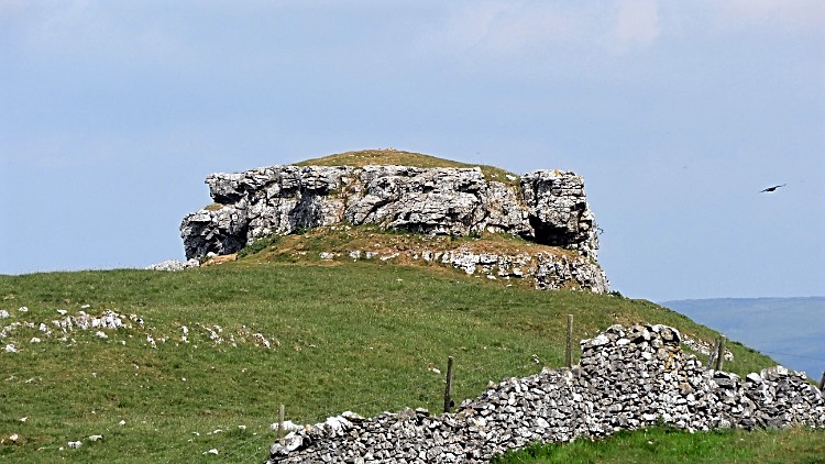 Conistone Pie
I continued my crossing of Old Pasture, ambling and observing as I walked. A Curlew took interest in me; I must have been near its nest. It led me off and away from its ground treasure in the usual way, swooping, coming to ground nearby and falsifying distress when back in the air with its familiar alarm call. I duly followed its lead and walking where it led me, never wishing to disturb a nesting bird. After the episode with the Curlew I listened to a Skylark singing, high and filling the sky with its delightful sound. There is no better sound for me to enjoy when I walk alone across open ground in the season of their song. I love it. When high in the Eastern Fells of the Lake District a Skylark sat on a fencepost and while I stood still close by it sung for me. If only I could have frozen time. After my avian encounters I arrived at Conistone Pie. It is a high limestone outcrop. It looks like a pie.
 View from Conistone Pie to Cote High Moor
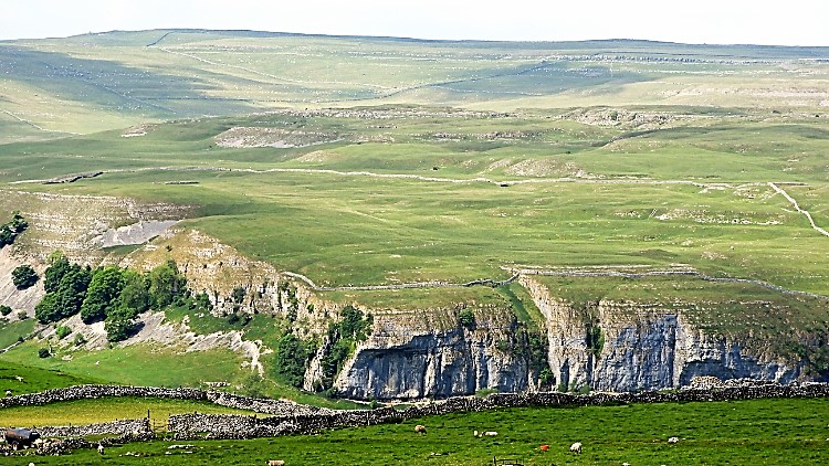 View from High Castles Scar to Kilnsey Crag
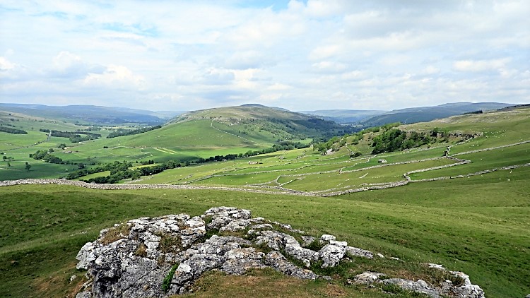
I always have to climb to the stand on the grassy crust on top of Conistone Pie. Almost everyone does, the small rounded limestone outcrop demands attention and gets it. And to give it credit, the view it provides is an exceptional one. Once standing on top of the pie this time I was immediately drawn to look north-west along the line of Littondale to turn my head slowly to the north, along the line of Upper Wharfedale. Seduced by the view of the hill mass dividing the two I looked over the south flanks of Cote Hill Moor. The day which had began with cloud was now more blue sky and therefore the visibility was superb. Everywhere I looked the scene was awesome. I looked northward once more before coming down from the pie. To Cote Hill Moor once more and to the highlands of Buckden Pike too. I imagined the times I attempted both in deep snow. I coped with Cote Hill Moor. Buckden Pike beat me as a blizzard had then forced me back. Much different it was today. A glorious sunny and warm day was evolving, the first day of June 2018. Leading myself across the top of High Castles Scar I viewed the scene west to Kilnsey Crag and the widespread moors of Hawkswick Clowder beyond the cliffs. Another site of wonderful wandering.
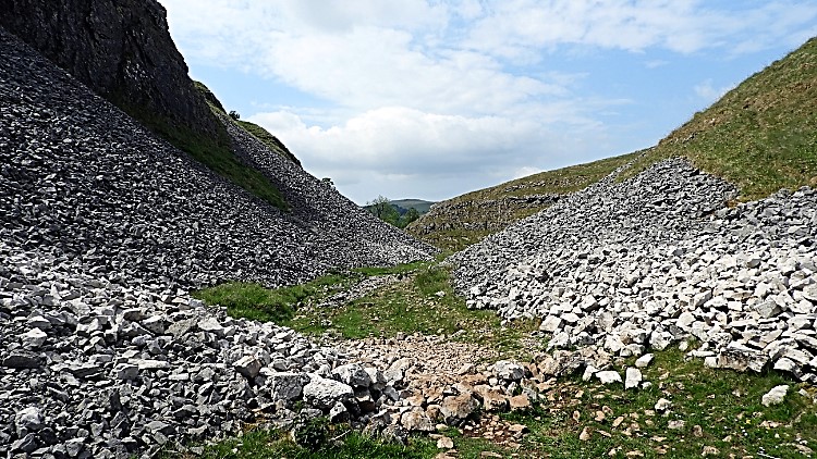 Scree fall from Bull Scar
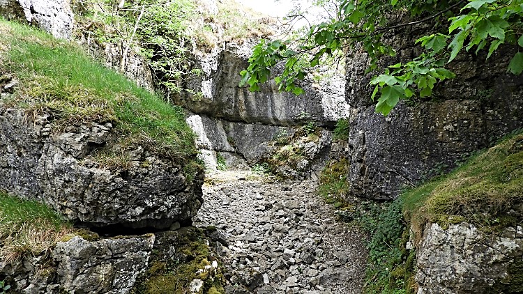 Conistone Dib
I led myself off the moor and prepared myself for the next piece of excitement on this walk which would not stop giving. Wow, if the thrills of the medieval sites, limestone pavements, ancient agriculture, birdsong and view finding had not been enough then much more was yet to come. And first up was the thrilling adventure of walking through Conistone Dib. The first time I had walked though the narrow dry limestone gorge I was dumbstruck. Within the Yorkshire Dales only here and in the squeeze of Troller's Gill do the cliffs close in on you so intimately. They are dramatic because of the intimacy. Neither here nor at Troller's Gill are they intimidating. The squeeze of Troller's Gill is not long, as soon as you are in you are coming out. Conistone Dib is lightly longer and thus slightly better. Both are friendly, welcoming, embracing gorges. Small and yet big at heart. Conistone Dib, if coming down from the fells is preceded by a picturesque wall of scree, most of it sheared of Bull Scar. I love the prelude.
 Emerging from Conistone Dib
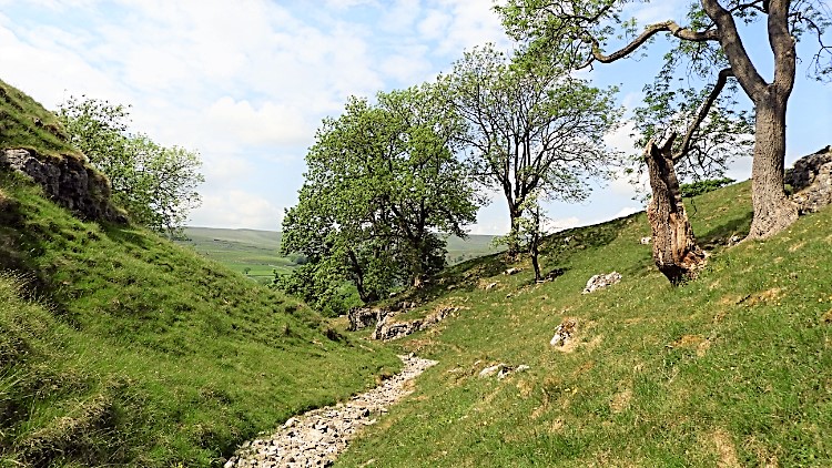
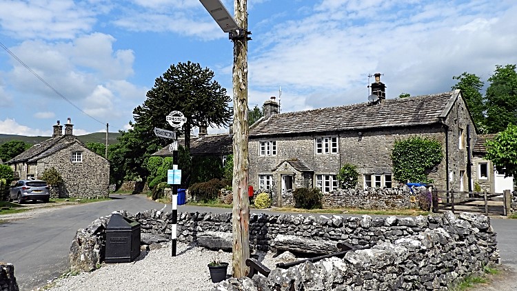 Conistone village
I love the short walk from Conistone Dib to the village of Conistone too. The gorge opens out as quickly as it closed in to reveal as lovely a dry valley as one could imagine. The first part of the reveal is a walk on a narrow bleach white limestone pebble path set either side of lush grassy banks with trees inviting the procession to the village. Some are old, some shattered trunks with defiant twigs of green growing out from the old parent trunk. Others are younger trees, springy and waving in the gentle breeze. A delightful sight. Some steps down from the path over limestone levels lead into the village itself, an assembly of individual and characterful homesteads. In the centre of the quite village, by the very quiet road running on the east side of the River Wharfe is an area of seating. It invites rest and I took it, now halfway through the walk. Bring your own tuck if you do this walk though. There are no shops in Conistone. Only peace and quiet.
 Path through Dib Gorge
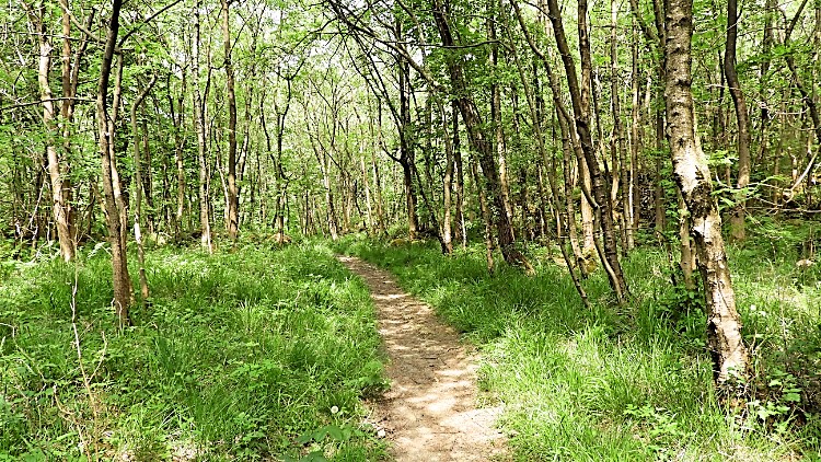 Grass Wood near Grassington
Suitably refreshed I left Conistone by heading south, first walking a short distance along the road and then by continuing by leaving the road, following the path climbing to the lower west side of Dib Gorge. It is a delightful climb, the first part on the side of fields and then on the centre part of fields, a climb of around 70 metres, the last part salivated by the anticipation of coming into lush green woodland which has sprung into view. First though Dib Gorge must be crossed which is achieved by turning up and into the dry gorge, Dib Beck only shows itself lower down, and climbing eastwards to nearly the point where Dib Gorge was crossed earlier on. Only a dry stone wall separates the paths. The climb up was short and stiff, as it had been earlier, this time bringing me to ancient woodland. I turned from south and followed the path south-west into Grass Wood Nature Reserve. Grass Wood, predominantly ash woodland growing on a series of limestone terraces, with areas of exposed rock is a maze of paths inviting one to explore. I could easily have got lost and here my GPS served me well as I followed my chosen meandering course as I had designed. It led me to the site of a prehistoric settlement at Far Gregory Hill. I could not make much out in the scattering of rocks and made my way down to the river. The woodland walk had been delightful, not least watching a group of men on all fours scouring the grass for rare wild flowers. And the dog which followed me rather than its owner. I really had to shoo it back to her.
 River Wharfe near Kirk Bank
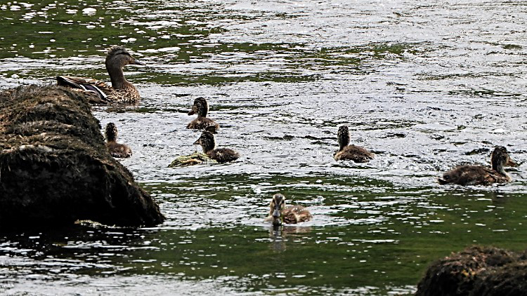 Family outing on the Wharfe
I came down from the woodlands and reached the River Wharfe near to Kirk Bank. First I followed it downstream by way of a woodland path. Sometimes I could see the river and sometimes I could not, the riverside bank of trees thick enough to shield my view. It was good fun though, following the path through the tree line in anticipation of open field and riverside walking a little further on. The path through wood had an unexpected final climb over a small hill before the woodland ended and ceded to open land. Now I could see my way across fields and beside a calmly flowing river. The Wharfe was in a good mood. The warming day and promised sunshine which now beamed down had brought out plenty of people. My quiet walk of solitude had now been replaced. Two separate couples were sitting beside the river. Both sets of partners just sitting and watching the river flow. Nearby a mother duck and her new family explored the river. I counted six young, not so much ducklings but youngsters. Their chances of maturing to adults looked good to me. I ambled along following the river downstream. The grand finale to my walk was just ahead.
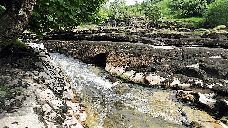 Ghaistrill's Strid
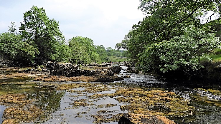 Downstream of Ghaistrill's Strid
I arrived at Ghaistrill's Strid. How had I never known of this place? It was dramatic, the wide and peaceful River Wharfe reducing to a narrow gorge with the narrowed flow of water rushing through at quite a pace. Being in the open and not quite as dramatic as its namesake and more well known woodland surrounded, high gorge Strid near Bolton Abbey, Ghaistrill's Strid is still quite a sight. Even at low flow levels such as these I was seeing for the first time. I followed the line of the channel chute which is Ghaistrill's Strid until it opened out back into wide river. And what a contrast. Just beyond the choke the river was quiet, placid and like a paddling pool. It was hot now, just after one in the afternoon. I took off my boots and socks and I walked into the river. It was gorgeous. I wandered around in the cool waters, watching tiddlers swimming around my feet. Such fun. Just beyond my rock pool I watched more people playing in the river. Some were swimming. Others were floating along in large inflatables. More were sat as I had seen before and as some were beside Ghaistrill's Strid. Watching the river flow. I did not want to put my footwear back on and leave but such is life I had to. I resolved to return with Lil. She would love a walk to Ghaistrill's Strid.
A short walk beside the river back to Grassington and my walk was done. There was so much to look back on, highlight's galore. Grassington, the site of a Medieval village, limestone pavements, gorges, cliffs, pies, dibs, woods, prehistoric settlements. How shall I end this piece? I know, I shall repeat the words of a well known android who said "I'll be back".


