Whitby, Ruswarp, Stainsacre, Widdy Head and Saltwick Nab
A walk of significant diversity which begins in the port of Whitby. The walk begins by following the railway line to Ruswarp and then takes a course over country to Stainsacre and Whitby Laithes before heading to the final section along the Yorkshire coast. A detour to Saltwick Nab is an option if the tide allows.
Google Maps Open Source Maps| Statistics and Files | ||
|---|---|---|
| Start: Whitby | Distance: 8.9 miles (14.3 km) | Climbing: 336 metres |
| Grid Ref: NZ897114 | Time: 4 hours | Rating: Moderate |
| GPX Route File | Google Earth File | About Whitby |
| Statistics | |
|---|---|
| Start: Whitby | Distance: 8.9 miles (14.3 km) |
| Grid Ref: NZ897114 | Time: 4 hours |
| Climbing: 336 metres | Rating: Moderate |
| GPX Route File | Google Earth File |
Ordnance Survey Explorer Map (1:25,000)
The Walk: My wife had asked "Where would you like to go for your birthday this year?". It did not take me long to arrive at an answer "A couple of days at the seaside would be nice. If we set off early on Friday I could go for a walk in the area and then we would have my birthday free for whatever we choose to do together". There was quick agreement to the suggestion so the only outstanding issue was to where we would go. Not wanting to drive for more than four hours each way we agreed on the Yorkshire coast. Then we agreed on Whitby. I peered over the map, designed my walk to feature both countryside and coastline, and then on the Friday we travelled over and arrived at our destination. After walking down to Whitby harbour and while having coffee and cake in a local cafe we agreed a meeting time and point for later in the day. Then after finishing our refreshments my wife set off to enjoy herself exploring the shops. I set off the explore the local environment.
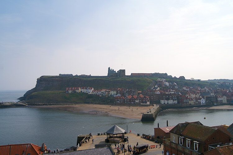 The view across Whitby Harbour from the start
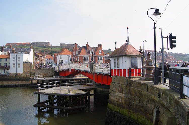 Whitby Swing Bridge
It was a gorgeous day, both sunny and warm, the first of the new Spring season when people could comfortably walk around the town in t-shirts and shorts. Many took advantage of the great weather; the harbour and low town busily thronging with people. From my starting point up above the harbour beside the Whalebone Arch all the way to my first reference point at Whitby Swing bridge I was busily employed in sidestepping groups of people who were casually meandering the streets. They added more than a few extra steps to the start of the walk, fun though it was observing the goings on and unconscious rituals of holiday makers. Activities such as wiping melting ice cream off toddlers faces, crabbing over the harbour walls and simply standing in the middle of footpaths looking around aimlessly while moving pedestrians side-stepped onto the road to avoid walking into them. The side-stepping continued from the swing bridge and past New Quay until I reached the round Tourist Information Office building at Endeavour Wharfe.
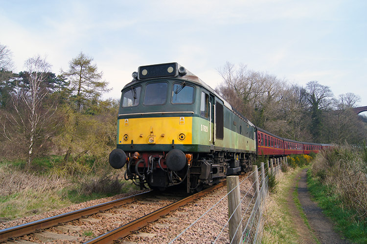 Diesel train on the Whitby line
 Ruswarp
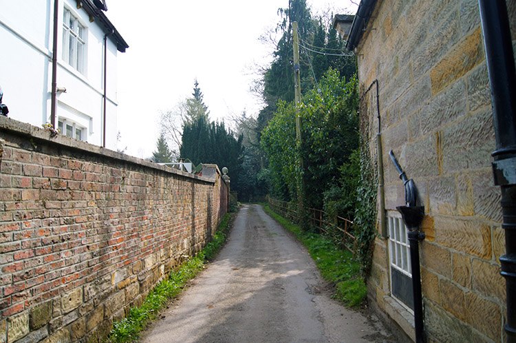
After leaving the area of Endeavour Wharfe there occurred the first clear change to my walk. Noise of people subsided as I left the throngs of holiday makers. and day trippers behind. It was replaced by the natural sound of coastal regions and particularly by the squawks and calls of Herring Gulls soaring above the River Esk. I walked upstream along the Esk to the end of Langborne Road and then past a strip of land with parked cars to my right and parked boats to my left which led me to a footpath running beside the Esk Valley Railway line linking Whitby to Middlesbrough and the wider National Rail network. As I walked along the line and out of town towards Ruswarp a few groups of people passed me going the other way. The first was a lady with her dog, the second a mature couple and the third a younger couple with two children. The fourth encounter was a single man laden down with lots of camera equipment and seemingly in a hurry. Soon on passing me he stopped and prepared to shoot the camera by leaning over the railway fence. Almost immediately after a tootle from a train whistle explained his haste. I ran away from the direction of the oncoming train for about 50 metres to find a suitable spot to view the curving railway line myself. I was just in time to get a suitable spot when the train came around the corner, a grand old Green and Yellow Diesel train so familiar to me in my youth. What timing, I caught a perfect view of the train and the assembly of old fashioned red carriages it hauled. It was a childhood memory moment, very nostalgic. My walk had started well and I walked along the footpath happily beside the railway line until I reached Ruswarp.
 Walking through Golden Grove
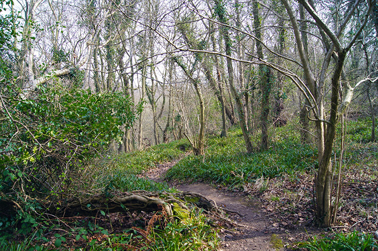 Cock Mill Wood
Ruswarp is an interesting village with impressive road and rail bridges over the River Esk. I was required to cross the road bridge, after which I turned left to follow the B road linking the village to Whitby on the south side of the Esk. It was not busy at all but had a few irregular slow touring cars on its undulating winding course which I kept an eye on until I left it to follow the dead end road south-east to Golden Grove. This road immediately led to the first and only real climb of the walk, a stiff 40 metres ascent in just a couple of hundred metres distance. Not much you might think but after the lethargy of level ambling a reminder to the lungs. The gain in height, albeit still to less than 50 metres above sea level, was enough to give the walk an upland feel though. Down to my left was a sweeping bank to Cock Mill Wood. I was above the trees down there. The day remained wonderful and I reached the isolated hamlet of Golden Grove, a haven of complete calm. I walked past the small scattering of habitations in almost complete silence. The exciting and all too welcoming twittering of small birds heralding the onset of Spring broke the peace. It was great. I continued past Golden Grove and soon the tarmac gave way to unmade track. Almost concurrently I left the road to follow a winding path into Cock Mill Wood. Exceptionally beautiful birdsong continued to draw me along the woodland path.
 Footbridge over Stainsacre Beck
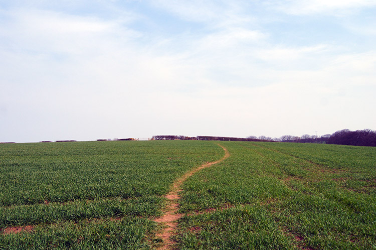 Across fields to Whitby Laithes
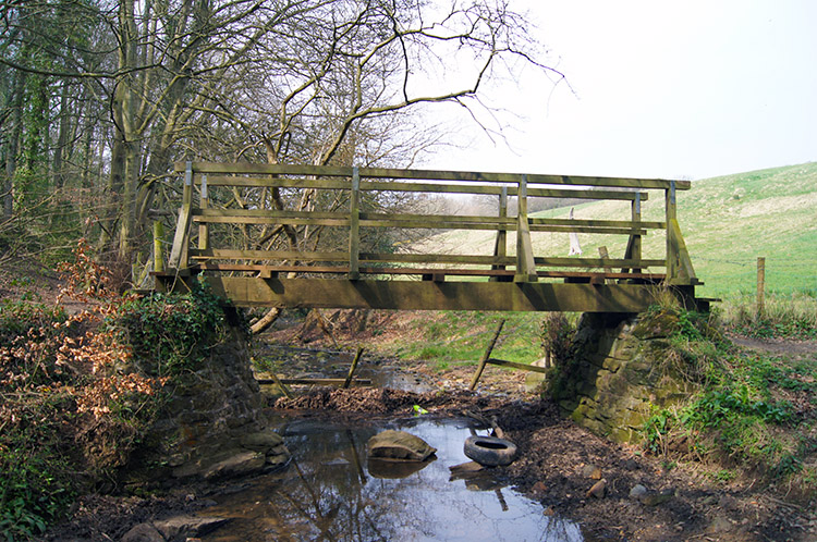
I followed the narrow meandering woodland path to a meeting of footpaths. Taking the one going south would have led me to Long Rigg with access to Hawsker. Not my destination though I had been in Hawsker once before when out walking, as a matter of fact on my first long distance path walk, the Coast to Coast all those years ago in 1994. I took the path leading east to Stainsacre. First I had to cross Stainsacre Beck but I did not need the use of the wooden footbridge which would have kept me high and dry above the waterline. I simply carefully stepped on a couple of steady stones positioned above the trickling waterline and stepped over the beck. I then followed the path which was now an unmade lane to the village of Stainsacre, another quiet place since being bypassed by the busy A171 Whitby to Scarborough road. After leaving the peace of Stainsacre this was a road I had to cross myself but after picking out caravans approaching from either direction with faster cars frustratingly lined up behind them I crossed calmly to the other side. This gave me access to a series of pastured and arable, newly cultivated fields which I walked along the side of, or crossed diagonally in the direction of Whitby Laithes.
Just before I reached Whitby Laithes I came across a couple of stone mushroom shaped concrete pillars beside a field side hedge. The one in my field was marked Little John. The one in the adjoining field was marked Robin Hood. I was intrigued and on checking the map I noticed I was walking across Little John Field. The field with the other pillar was Robin Hood Field. (Subsequently on research I have found out the pillars represent the assumed points where arrows fired from longbows by Robin Hood and Little John from Whitby Abbey landed. They were being entertained at Whitby Abbey at the time and performed the feats as entertainment. If the story was true the range they achieved was 1.4 miles, 2.2 kilometers, a full mile further than the known record. See Britannia Online)
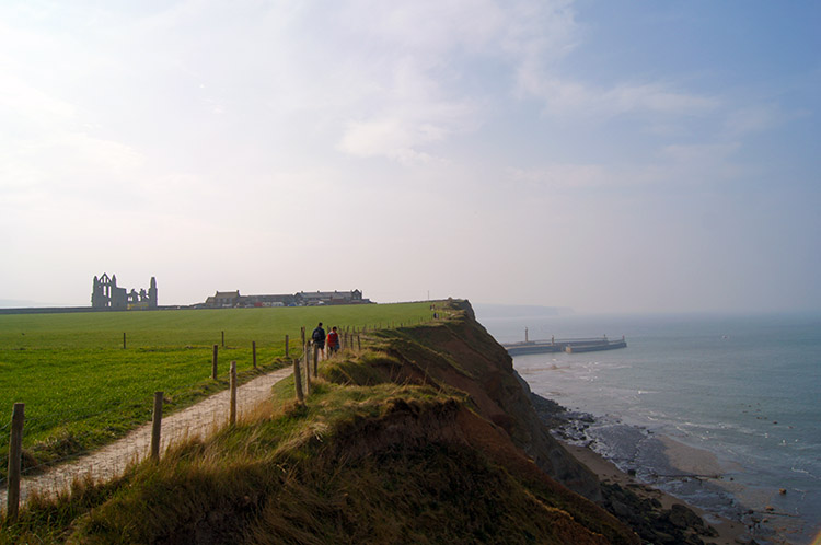
 Approaching Widdy Head
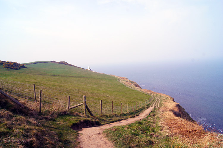 The coast path to Whitestone Point
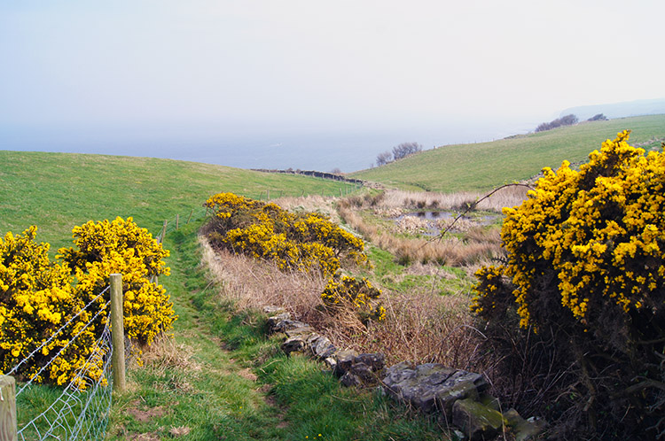
From Whitby Laithes I crossed Hawsker Lane, the only traffic on it being an elderly lady walking sedately and accompanying an elderly gentleman moving slowly along the road in a mobility vehicle. He put the vehicle into neutral and said hello. We chatted for a while, he was clearly enjoying being outdoors in good weather. After our short but amicable conversation he wished me well on my way, as I did to he and his lady friend. Such meetings are brilliant interruptions to a walk. On leaving the couple to continue their leisurely time outdoors I followed the path which took me due east past Manor House Farm and Whitby Laithes Farm to the North Yorkshire coast at Whitestone Point. On the way I past smatterings of blossoming gorse adding a brilliant yellow to the outbreaking spring colour of new growing grass and burgeoning buds of hawthorn trees.
 Whitby lighthouse
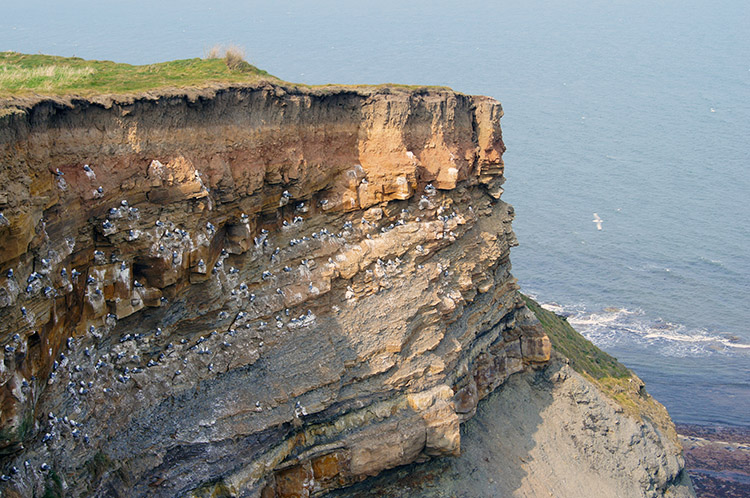 Cliff claimed by Gulls at Whitestone Point
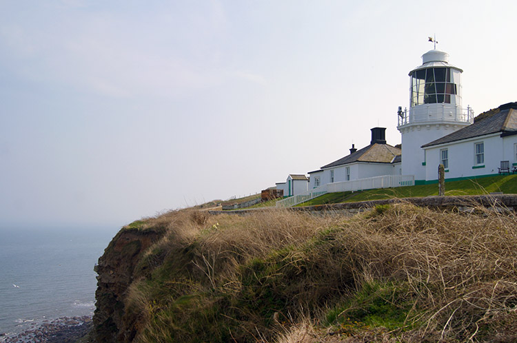
As I joined the coast path I had also joined the Cleveland Way. The path, 109 miles long, is one of two parts, the first half of which I have walked nearly all crosses the North York Moors from Helmsley to the North Yorkshire Coast at Saltburn on Sea. The second half follows the Yorkshire coastline south to Filey. I have probably walked half of the coastal section. This was a new part of it for me. My first point of interest was Whitestone Point Lighthouse. Only by looking at the map when planning the walk did I become aware of it. I was impressed when I first sighted it, shining in the sunshine in brilliant whitewash. Also known as Whitby Lighthouse or South Whitby Lighthouse and Whitby Fog Signal station first shone out light to passing ships in 1858. It still shines today.
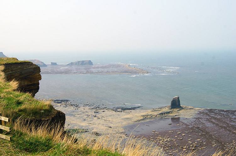 View to Black Nab and Saltwick Nab
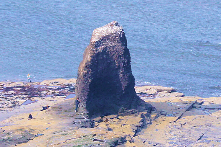 Black Nab
Soon after passing Whitby Lighthouse I continued along the Cleveland Way path heading north along the coast and above the cliffs, often stopping just to take in the view and the moment. Gulls soared alongside me, gliding on the thermals created by the cliffs. Their seemingly effortless flight was so impressive to observe. They would dip into and out of my sight as if riding a roller coaster. When they were lower than the eye line of the cliff top I missed their grace and then up they would swoop again providing me with a free aerial display. Many were younger birds, still with black mottling on the feathers perfecting their soaring skills. Some parent birds flew alongside their young proudly. s well as the stunning performance of the birds I was captivated by the natural shape of the coastline. Below I could see Black Nab a single protruding stack of rock standing proudly above the flats of Saltwick Nab. A group of people admired it up close. Seeing them made me want to be down there at sea level too.
 Saltwick Nab
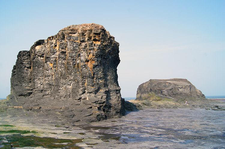 Saltwick Nab is accessible during low tide
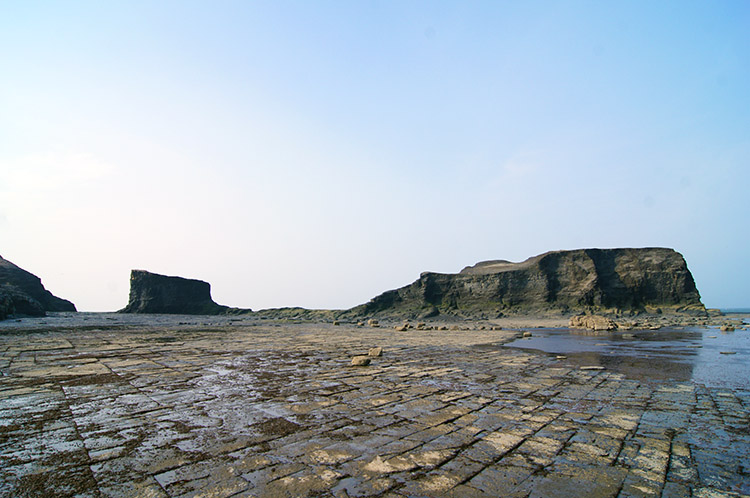
I was lucky. The tide was out and people were already out wandering on the flat natural pavements of Saltwick Bay which stretch out for hundreds of metres to the sea when there is ebb tide. This meant I could leave the coastal path above the cliffs and follow the clear path down to mean high water level. From there I crossed the easy pavement of North Batts to reach Saltwick Nab. The outcrop of rock on the outer lying nab, half the time an island and half the time fixed to the mainland was enticing me to climb it. So I did, all the way up and across a narrow ledge onto the main body of rock. It was a surreal feeling. The rock itself is shaley and crumbly with millions of tiny unfixed pieces. Totally unlike anything I had walked on before. Still it was a marvellous experience and from the top I looked across to the cliffs and to the path from where I had come. I veered around north to follow the path I had yet to take on my walk back to Whitby. I swung around more to look out to sea and watched a couple of tanker ships moving slowly across the horizon. Continuing around I looked south to Black Nab, the impressive obelisk outcrop I first noticed. Much smaller than Saltwick Nab, the sea will probably perish it first but not before millions more have enjoyed being up close. I stayed on Saltwick Nab as long as I could, reluctantly leaving as I had one more place to explore. I knew my wife would be waiting if I were much longer.
Note - the gpx route file and Google Earth kmz file follow the path on the cliff top. Only if it low tide and safe can you take my diversion down to Saltwick Bay and to Saltwick Nab.
 Cleveland Way towards Whitby Abbey
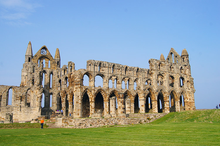 Whitby Abbey
I climbed back up to the cliff top path along the Cleveland Way by means of a well used route which had eroded a little bit. The solution? Some good soul had fixed a ladder to a section where the path had collapsed. It was fit for purpose, well done. I walked on briskly towards Whitby. Before Saltwick Bay I had been on a solitary walk all the time since leaving Whitby. Now people were back amidst me, the Cleveland Way path from Whitby to Saltwick Bay is popular. Some I passed while they walked south, others I overtook as they walked north. A couple of strolling groups impeded my progress temporarily. until they noticed I was upon them that is; the path is narrow and if breezy an approach from behind cannot be heard. Perhaps I needed a whistle. During this phase of progress I had my attention fixed on Whitby Abbey. I had been up close a few times but I had never been in. This time I would pay a quick visit. Tomorrow with my wife I would dwell. And so I called into the Abbey grounds and I thought about this time of year. It was now near to Easter and the timing of our Easter weekend was determined here at the Synod of Whitby in the 7th century. Despite its claim to fame the abbey could not be saved from Henry VIII's wrath during the Dissolution of the Monasteries.
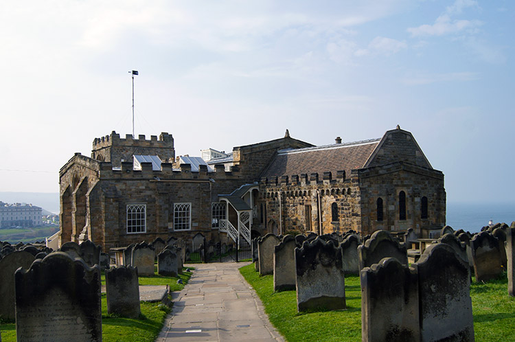 Church of St Mary, Whitby
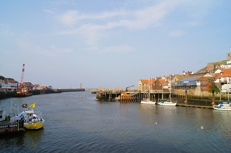 River Esk seen from Whitby Swing Bridge
After my brief exploration around the grounds of Whitby Abbey I walked the final phase of my walk back into Whitby town. I did this by following Whitby's famous 199 steps past the Church of St Mary to the throngs of holiday makers., day trippers and local citizen shoppers crammed on the narrow road of Church Street. I made it past unscathed and from Church Street I crossed the Swing Bridge to follow St Ann's Staith and Pier Road back to the steps which would lead me back up to the Whalebone Arch. Once I had climbed up to them I sat for five minutes looking out on the bustle of the town below. I reflected on my walk and banked the thought of how I loved every single step of it. Countryside, coast, geological wonders, history, lovely people, birdsong. All of it.


