Blairmore, Cnoc Poll a'Mhurain, Am Buachaille and Sandwood Bay
This walk is often hard going and parts of it are over rough unpathed terrain but it never seems overly difficult. Attention to detail is required though and map skills are needed if not relying on a GPS unit because there are no paths to rely on between the scattered settlement of Sheigra and the coast at Port Beag. Bar the trig pillar on Cnoc Poll a'Mhurain that is. The walk northwards along the coastline from Port Beag to Sandwood Bay is immensely fulfilling with stunning views to sea, to the sea stack of Am Buachaille, to Sandwood Bay and beyond stretching all the way to Cape Wrath. After the enjoyment of Sandwood Bay the walk back on the good track to Blairmore which goes by a series of lochans is the perfect ending to a great walk.
Google Maps Open Source Maps| Statistics and Files | ||
|---|---|---|
| Start: Blairmore | Distance: 10.8 miles (17.4 km) | Climbing: 521 metres |
| Grid Ref: NC 19450 60049 | Time: 4-5 hours | Rating: Hard |
| GPX Route File | Google Earth File | About Sandwood Bay |
| Statistics | |
|---|---|
| Start: Blairmore | Distance: 10.8 miles (17.4 km) |
| Grid Ref: NC 19450 60049 | Time: 4-5 hours |
| Climbing: 521 metres | Rating: Hard |
| GPX Route File | Google Earth File |
Ordnance Survey Explorer Map (1:25,000)
The Walk: It took just over five years to right a wrong. My original plan for the second stage of my Great British Walk which I completed over three months in 2011 was to cross the Kyle of Durness and walk to Kinlochbervie via Cape Wrath and Sandwood Bay. When I reached the Kyle though I could not cross due to adverse weather conditions. Thus I missed out on Cape Wrath and on Sandwood Bay too which I had so much wanted to visit. So, five years later, in the summer of 2016, I returned to south-west Scotland to visit the places I had missed out on. With Cape Wrath already bagged I designed this circular walk to accomplish my goal of visiting Sandwood Bay. And as a bonus I added in the walk to Am Buachaille which, had I done as I had planned in 2011, I would have missed out on. It was a win win situation.
 Following the road to Sheigra
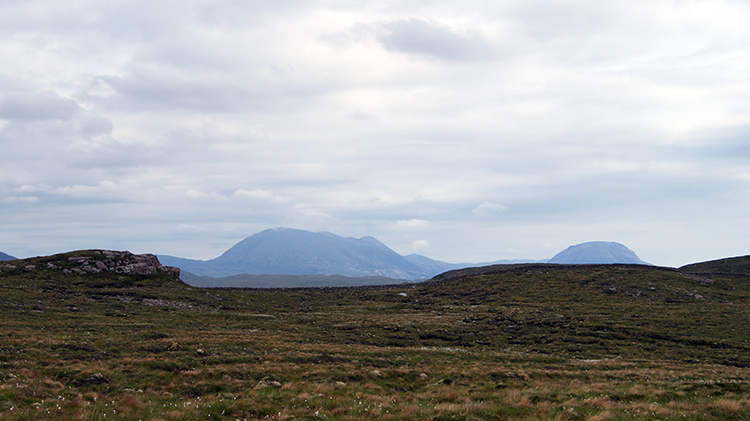 View to Foinavon and Arkle
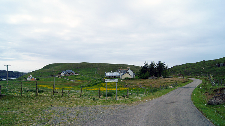
It had been a wet morning, having been woken in my tent in Durness by the pitter patter of raindrops hitting the canvas. It was not too bad though and the forecast was an improving picture. While the promised fine weather was making its way to me I took the opportunity to cross the Kyle of Durness and visit Cape Wrath. So that bucket list item was ticked off in the morning. After the visit to the lighthouse and after my return across the Kyle of Durness I made my way to Blairmore. Though it was still overcast at 2.20pm when I set off on the walk from the car park at Blairmore I could see clear blue skies to the far west in the Atlantic Ocean. The clouds were going as I got going by walking along the quietest of roads to Balchrick and to the end of the road at Sheigra. I did not meet cars on the road, all I met was sheep. Beyond the village of scattered bungalows and static caravans I followed a rough track heading south-east to Cnoc Poll a'Mhurain. The track continued around the hill to the north side and died out. I climbed Cnoc Poll a'Mhurain before the end of the road.
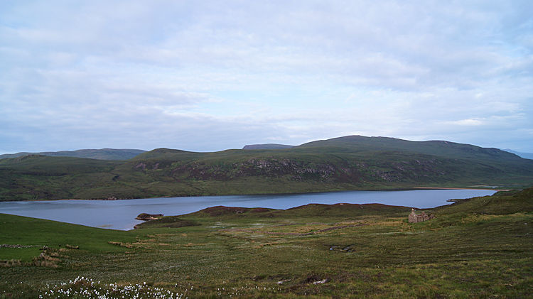
 Cnoc Poll a'Mhurain
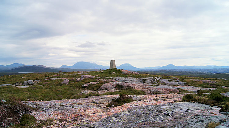 The mountains of Sutherland
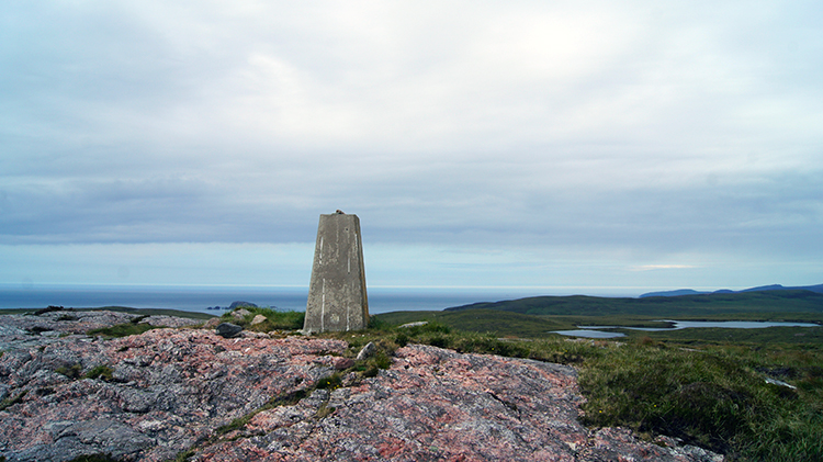
It was eerily quiet on Cnoc Poll a'Mhurain. Apart from the seabird poo covered trig pillar set at a height of 153 metres, the surroundings were completely natural and still. There was little wind, only the faintest of breeze which I could hear whispering as it passed over the ground. I looked all around me. Due north and beyond the coastline I could see nothing but the sea. By turning my head in a clockwise direction the lighthouse at Cape Wrath came into the picture. It was shining bright white in the sunshine touching the south-west edge of the British mainland. It had been gray when I had been there earlier in the day. Turning to look east I eyed the first significant mountains of Sutherland which included Beinn Spionnaidh, Cranstackie, Foinavon, Arkle and Ben Stack. All were mountains I became familiar with on my Great British Walk. It was nice to have them in my attention again.
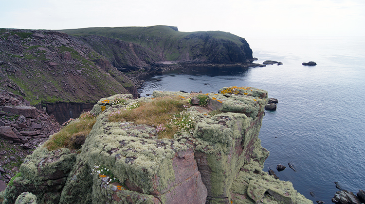
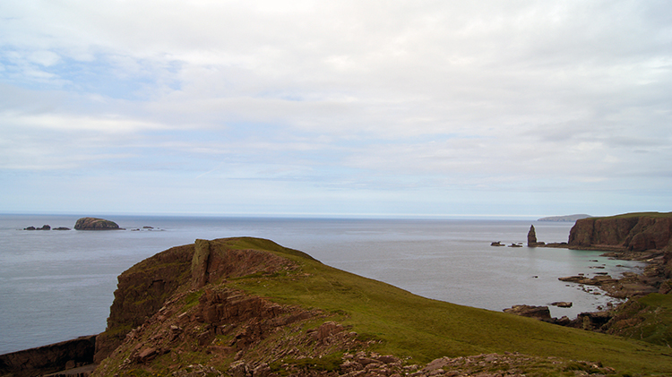 Rubh' an Fhir Leithe
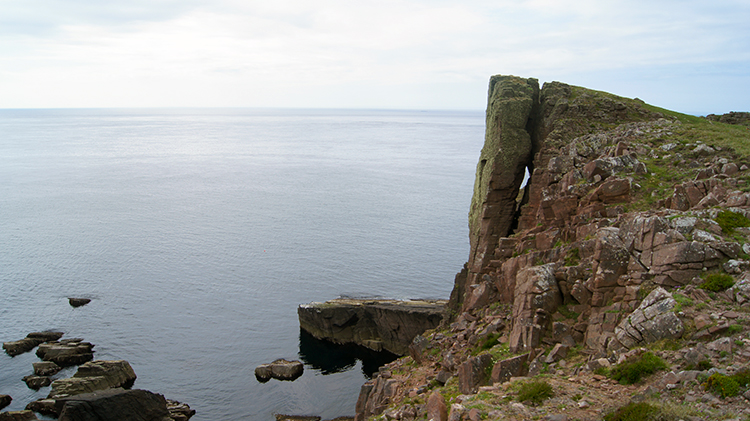 Detached cliff
I stood for quite a while admiring the view from near the trig pillar on Cnoc Poll a'Mhurain. It was a spectacle to take in. After the show I fixed my attention on heading on a calculated bearing towards the coastline at Port Beag. Having set the bearing I fixed my eyes on the protruding outcrop of Rubh' an Fhir Leithe and walked in a beeline towards it. After a few ups and downs between raised tufts of course grassland and peaty hollows I made my target at the coastline. I looked northwards up the coastline and soon spotted the sea stack of Am Buachaille. The small island of Am Balg also captured my attention. I looked forward to getting closer to them but before then I walked to the topmost point on Rubh' an Fhir Leithe and sat down looking out to sea. It was magical and though it was now 3.30 in the afternoon I was in no hurry. It would be light for hours yet and perhaps all night if the moon was full. Mid June in far north-west Scotland is like that. And I had only to get back to my tent after the walk anyway. "Why not enjoy it out here" I thought to myself.
 Port Beag
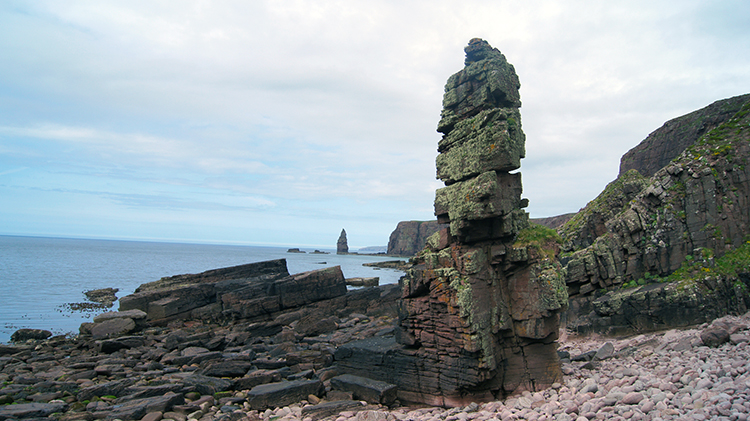 Sea Stacks
I got to my feet eventually and wandered from the south side of Port Beag to the north side at Rubha nan Cul Gheodhachan, a pointed outcrop between Port Beag and Port Mor. I suppose port means cove in these parts, both Port Beag and Port Mor being crescent shaped inlets between short headlands. Below Rubha nan Cul Gheodhachan I dropped down to the extreme shingle shoreline of Port Beag and admired a small unnamed sea stack. Or land stack? It shares times at sea and times awash. The tide dictated whether the foot of the stack would be submerged or not. Being stood besides the isolated stack of rock gave me a good aspect view to the more famous stack of Am Buachaille.
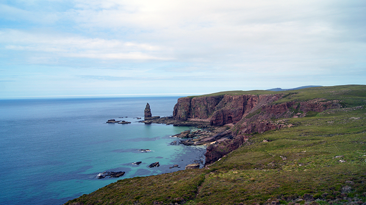 Port Mor and Am Buachaille
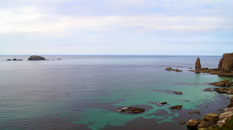 Am Balg and Am Buachaille
After climbing back up from the shoreline to walk above the cliffs between Rubha nan Cul Gheodhachan and Rubh' a Buachaille I ambled at a leisurely pace. This was such a quiet and peaceful place. Since leaving the car park at Blairmore where a few people had been bustling about I had been on my own. Even when walking though the scattering of habitation at Sheigra I had seen no one. It was if I was alone in the world and I was loving the solitude. I enjoyed the peace and quiet as I carried on walking. The going was easy and all was fine. The feeling of solitude changed though as I neared Rubh' a Buachaille. I sensed someone was around. Then I spotted two figures heading across the land from the east. They too were heading towards Rubh' a Buachaille.
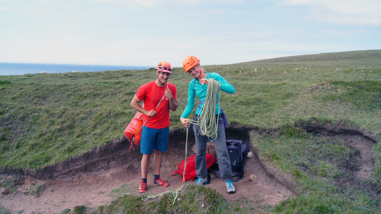 Alex and Katy
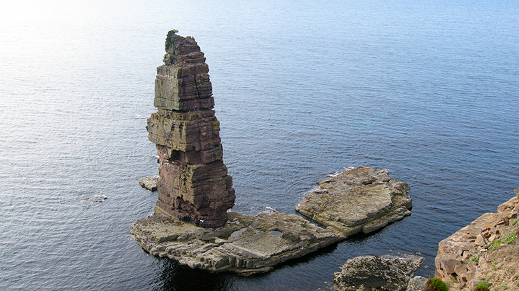 Am Buachaille (The Shepherd)
I met up with Alex from Llanberis and Katy from Sheffield in a cleft between cliffs formed by tow small anonymous lochans. The equipment they were carrying gave away their reason for being in this very remote place. They were kitted out for climbing and I immediately knew what their target was. As walkers have challenges such as completing the National Three Peaks in 24 hours, walking a National Trail or indeed walking on the full length of Great Britain then climbers do too. One such challenge is climbing the Three Scottish Sea Stacks of The Old Man of Stoer, The Old Man of Hoy and Am Buachaille. After greeting each other we chatted about our different passions and they went on to tell me climbing to the top of Am Buachaille would complete their quest. They had summited Old Man of Stoer and Old Man of Hoy earlier on their trip. I said that, having no rush to finish my walk, I would watch them climb to the top and give them a wave from my chosen vantage point.
As they scrambled down the rift in the cliff to the sea I walked around the head of Rubh' a Buachaille and found a good rock to sit on. I waited quite some time before I even saw the two young climbers again. It had been an effort just to get down to sea level safely and then as I looked down on the Lowry like figures I realised what a challenge they had. Am Buachaille which is 65 metres high did not look too big from where I was, at the greater height of 80 metres and looking down on the sea stack. Seeing Alex and Katy struggle just to get across to the base Am Buachaille, which necessitated a short swim to do, took them a good half hour. Then they were another fifteen minutes preparing to climb. Alex climbed first, one hour after we had first met. One hour and fifteen minutes later Alex waved across to me from the summit of Am Buachaille. Katy followed him up. Well done!
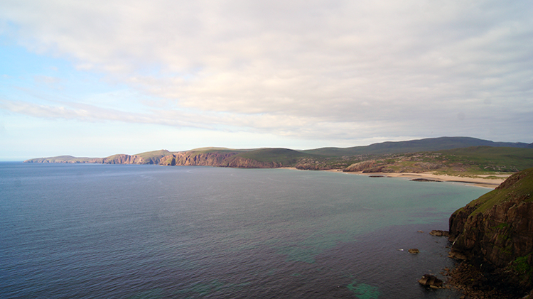 Cape Wrath and Sandwood Bay
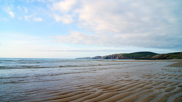 Sandwood Bay
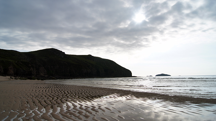
I waved across to Alex and Katy as they celebrated their moment of triumph on Am Buachaille and then I walked off into the early evening of north-west Scotland to attain my personal goal of standing on Sandwood Bay. It was 7.00pm when I left them, two hours after meeting the couple before their climb. The golden sands of the bay soon appeared in view before me though I could not be hasty in making the enticing straight line to reach them. There was a cliff between me and the beach which I had to sensibly skirt around. I also took my time to look across the gorgeous scene of cliffs and coast extending from Sandwood Bay to the far north-west tip of the mainland at Cape Wrath. Sun was warming the most northerly of the cliffs while a pesky cloud line partially sheathed Sandwood Bay from full sun. I wished it to go by the time I got to the beach.
As soon as I had safely scrambled down to the beach I was struck by the beauty of Sandwood Bay. The narrow sheath of cloud on the bay which turned the sunshine milky added to the character. I know there are many spectacular beaches in Britain and I have stood on many but Sandwood Bay struck me immediately as being amongst the best. I suppose isolation does that. And mystique too. Many walking and travel writers extol the positive virtues of Sandwood Bay. However, to add substance to my thought that Sandwood Bay is special here is what DEFRA's Geological Conservation Review say "The beach–dune complex of Sandwood Bay, north-western Sutherland is among the most dynamic in Britain. The high level of activity of the beach and dune landforms, in a situation where human interference is limited, is of great geomorphological interest. Sandwood Bay is enclosed by cliffed headlands to the north and south and contains a diverse assemblage of spectacular soft coastal landforms. To the landward side of the wide sandy beach, a gravel-cored bar capped with highly dynamic sand dunes impounds the freshwater of Sandwood Loch. Other features of interest include extremely mobile sand dunes with large blowthroughs and climbing dunes that reach altitudes of over 100m OD on adjacent hilltops (Ritchie and Mather, 1969)"
 Standing amidst beauty
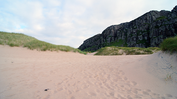 Climbing out of Sandwood Bay
I can vouch for all said by the geologists said about Sandwood Bay and I must add substance to it. The remarkable atmosphere of just being stood in the middle of the pristine tidal and firm on the feet beach of Sandwood Bay. There is no litter to be found here, people who visit this place, like I, would not think to sacrilege such a perfect setting. The feeling I felt as I stood and scanned the view sweeping from south, to west and to north, all across the seascape was beguiling too. I did not look inland. I was saving that pleasure for later. I just looked out to see and to the cliffs encompassing Sandwood Bay with a feeling of calm. Utter contemplation, complete satisfaction. Sandwood Bay is as special as the writers say and as special a place as I wanted it to be. My dreadful omission of 2011's Great British Walk was now overturned.
I found it hard to leave Sandwood Bay. Had I the tent with me I would have pitched up and stayed but the tent was pitched and waiting in Durness. It was nearing 8.00pm by the time I forced myself away from the beach. And as soon as I stepped from the firm packed sands to the loose sands above the coastline I went from easy walking to that which was terribly difficult. Dynamic sand dunes indeed. They dragged me down and it was a struggle to climb through them. Every step I took saw my boots completely disappear into the sand. With each step it took further effort to drag one boot out as the other boot sunk in. I followed previous walkers footsteps which, having suffered similar ordeal, had found a way up the dune hills to the less arduous walking in the loose tufted grasses formed on the crest of the dunes.
 Sandwood Loch and Sandwood House
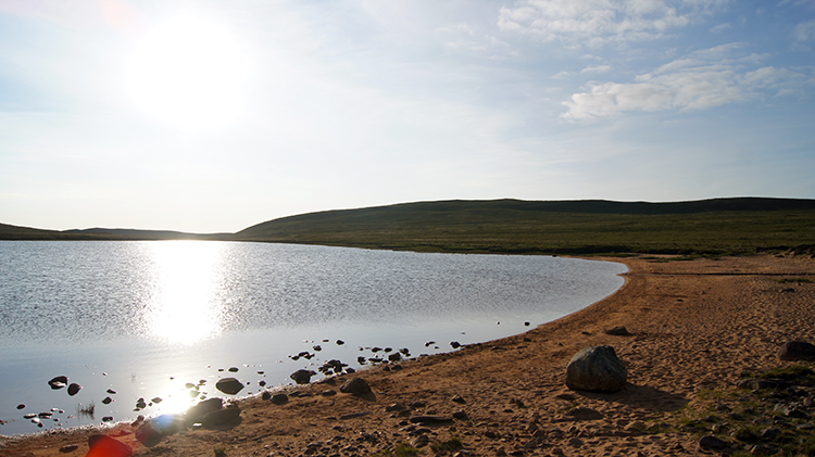 Loch na Gainimh
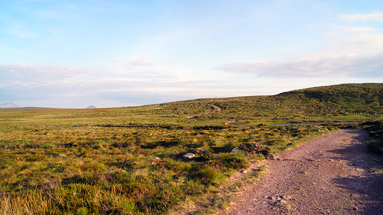
I clambered up 50 metres though the dunes and grasses, puffing all the way. And I noticed as I struggled on that sunshine was getting stronger. Every step I took inland took me from the veil line of the thin cloud which had gossamer covered the coast. Full sunshine and relief from walking through soft sand came simultaneously at just over 50 metres above sea level when I reached a discernible path near an inland cliff. Drawing breath I came to a sheepfold and spotted Sandwood Loch. It was a lovely sight to behold. Near to the loch stands the ruins of Sandwood House which dates from the latter half of the 19th century. The building was utilised as a farmhouse and I wondered when the last householder left the place to abandonment. Continuing on the path assumed a good and well managed appearance. Fitting as the John Muir Trust manage this path from Blairmore to Sandwood Bay. I followed the good path past small lochans, each one shimmering in the line of rays cast on them from the early evening sunshine. It was warm, it was peaceful and it was delightful. And I had it all to myself.
 Path back to Blairmore
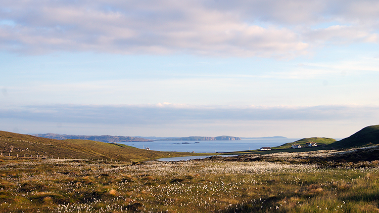 Kinlochbervie Bay
I walked past Loch Clais nan Coinneal, Loch Meadhanach, Loch a' Mhuilinn, Lochan Dubh and Loch na Gainimh, each one a little treasure along a path of treasure. That is what I thought of them as I walked along the sun-kissed path on my way back to Blairmore. It was approaching 9.00pm by the time I crested a bank south of Loch na Gainimh which gave me my first glimpse of Blairmore since setting off on my walk almost seven hours earlier. I looked beyond Blairmore and across the stunning sight of Kinlochbervie Bay. It was a fitting view to enjoy as I walked back into Blairmore and returned to the car park. I finish walking after 9.00pm but it did not feel like it. The sun was still in the sky and the daylight was still perfectly bright. As my thoughts were on the adventures of this stunning walk. It was everything I had wished for and more with Sandwood Bay the lead, Am Buachaille the co-star and with a supporting cast of exemplary players. WOW.


