Moelfre, Lligwy Bay, Capel Lligwy, Din Lligwy and Lligwy Burial Chamber
My first walk on the island of Anglesey begins in the pretty and popular coastal village of Moelfre. Starting off with a walk along the Anglesey coast from Moelfre to Lligwy Bay I then head inland to explore a few sites of archaeological interest including dwellings and places of worship. Anglesey is a hot spot for archaeology and the sites I would visit on this short walk around in the south-east corner of the island would give me a flavour of the past on the island. And of course the present as Moelfre has adapted well to suit modern life.
Google Maps Open Source Maps| Statistics and Files | ||
|---|---|---|
| Start: Moelfre | Distance: 4.3 miles (6.9 km) | Climbing: 113 metres |
| Grid Ref: SH 51190 86222 | Time: 2-3 hours | Rating: Easy |
| GPX Route File | Google Earth File | About Moelfre |
| Statistics | |
|---|---|
| Start: Moelfre | Distance: 4.3 miles (6.9 km) |
| Climbing: 113 metres | Grid Ref: SH 51190 86222 |
| Time: 2-3 hours | Rating: Easy |
| GPX Route File | Google Earth File |
Ordnance Survey Explorer Map (1:25,000)
The Walk:
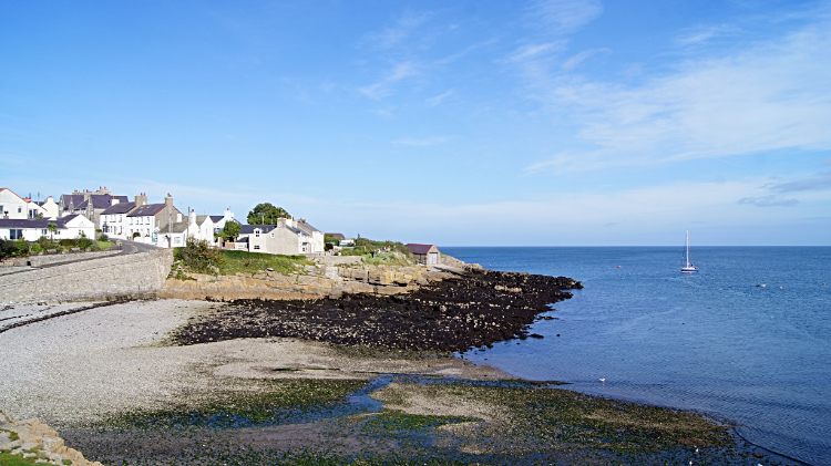 Moelfre Harbour
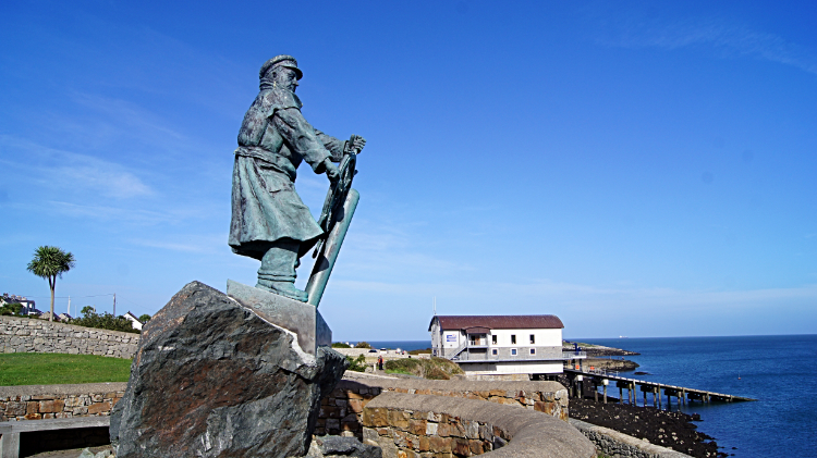 Moelfre Lifeboatman Statue and Seawatch Centre
It was a lovely sunny day in the first week of October when I crossed the Menai Suspension Bridge and visited the island of Anglesey for the first time. I was on a five day walking break in North Wales and having driven over from North Yorkshire I had just enough time for a two to three hour walk before leaving the island to find my accommodation in daylight near Porthmadog later on. I arrived in Moelfre at two thirty in the afternoon and after parking my vehicle up I set off walking down the road to the village harbour, passing a happy crowd of patrons sat in the garden area of Anns Pantry Cafe Restaurant on the way down to the village harbour. Straight away I worked the way from the harbour to the coast path. Following the path I passed a statue dedicated to the lifeboat men and then a memorial of the sinking of the Royal Charter when over 400 people died as the result of the steam clipper sinking in 1859 during a heavy October storm. So sad and hard to imagine as I looked out to a benign sea on such a calm sea at the same time of year as that of the tragedy. After paying my respect of standing in silence with head bowed I resumed my walk and continued on past the Seawatch Centre which is also the lifeboat house. Moelfre All-weather Lifeboat ‘Kiwi’ was in the building, spotless but surely reading for action.
 Following the Anglesey Coast Path
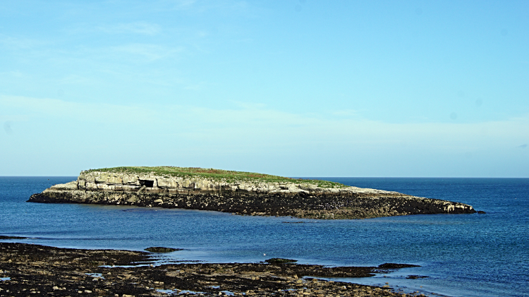 Ynys Moelfre
I had met a couple of people in Moelfre Harbour and I had chatted with some more while walking along the coast path to the Seawatch Centre but beyond the habitation it was just me and the birds. There were plenty of passerines such as Hedge Sparrows dipping in and out of the seaside path hedgerows as I walked along. Soon though my attention was focused out to the water as I gazed across the small reach of water to Ynys Moelfre (Moelfre Island) where I could see several groups of birds. Some in their own group and some mixing with others, all in the relative safety of the island. There were Cormorants and Shags co-habiting though I had no idea which was which. They looked the same to me from the distance I was on shore to what they were on the island. Gulls were on the island too. Great Black Backed, Black Headed and Herring Gulls frequent Ynys Moelfre and as I could not see any black on them I assumed them to be Herring Gulls. The type that nick peoples chips in Whitby. Noticeably the Cormorants and Shags preferred the higher ground of the islands grassy table top while the gulls rummaged in the waterside rocks of the lower island. A few Oystercatchers dipping in and out of water completed the avian scene which I stood and watched in interest for a good five minutes.
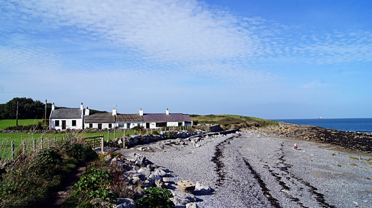
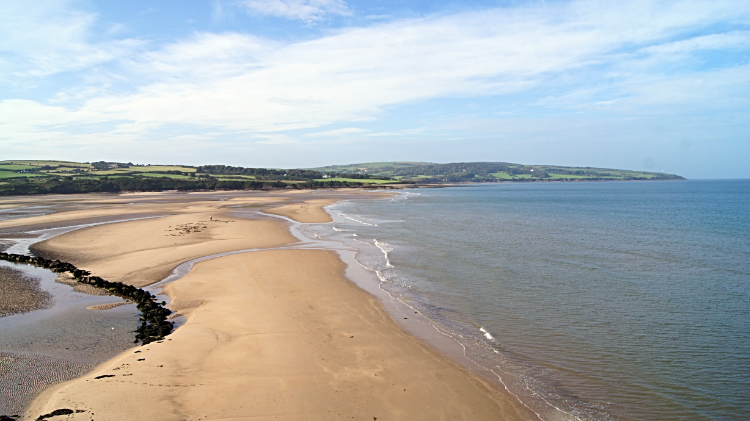 Lligwy Bay
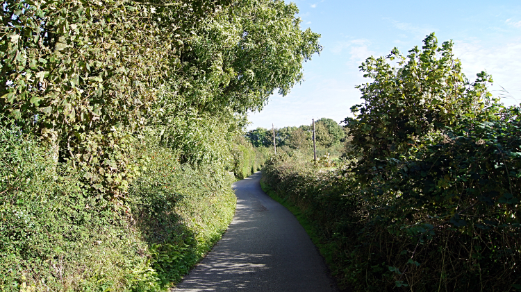 Road leading away from Lligwy Bay
From Ynys Moelfre I continued walking north along the coast path to reach the golden sands of Lligwy Bay. The bay is very popular with windsurfers and other wind powered watersport enthusiasts but surprisingly on such a lovely day there was nobody playing. Just one chap with a white plastic bucket and spade was on the sands digging. Possibly an angler looking for lugworms. I looked across the sands to the far side of the bay as another information board told me that is where I would find wreckage of the Royal Charter. I left the site in peace, now ending the picturesque coast path stage of my walk to head inland, toward the archaeological sites. On the way from Lligwy Bay I passed the water sports enthusiasts car park. Typically someone had artfully written on the whitewash wall of the car park toilets phrases such as "sun is shining in the sky; there ain't a cloud in sight; it's stopped raining; everybody's in a play and don't you know it; it's a beautiful new day... hey, hey, hey". I was quite taken with the jollity and the pure optimism of the words. "I am liking Anglesey already" I thought to myself as I walked from the car park and on down the road in the direction of those ancient sites.
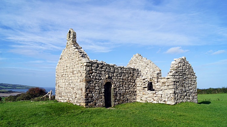 The ruins of Lligwy Chapel
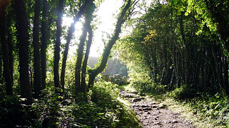 Woodland path to Din Lligwy
It was not a long walk down the road which was bereft of traffic. Even so, i passed a group of four elderly ladies enjoying their walk on this most gorgeous of afternoons in the Indian summer. Two of the ladies had dogs to exercise. The other two were out for the sheer enjoyment. On passing them I said hello and they all said hello back. We all agreed it was the best of days. Now four in the afternoon I still had a couple of hours of good daylight but not much more if I wanted to find my static caravan on the site near Porthmadog in the light. So I pressed on along the road, crossing a minor crossroads and following the sign indicating 'Din Lligwy Ancient Village'. A little over 200 metres further on I left the road, turning right into a field. Immediately I was taken aback by the beautiful site of the ruins of Capel Lligwy. The setting was ideal, the small chapel set on high ground overlooking Lligwy Bay. I took a brief look around inside, the building so small it only requires a sweep of the eyes. The vault was open but I did not go down. Though I did look. A cell of a few discarded rocks. Afterwards I crossed the field where the chapel stands to enter a gorgeous small woodland leading to the ancient settlement of Din Lligwy.
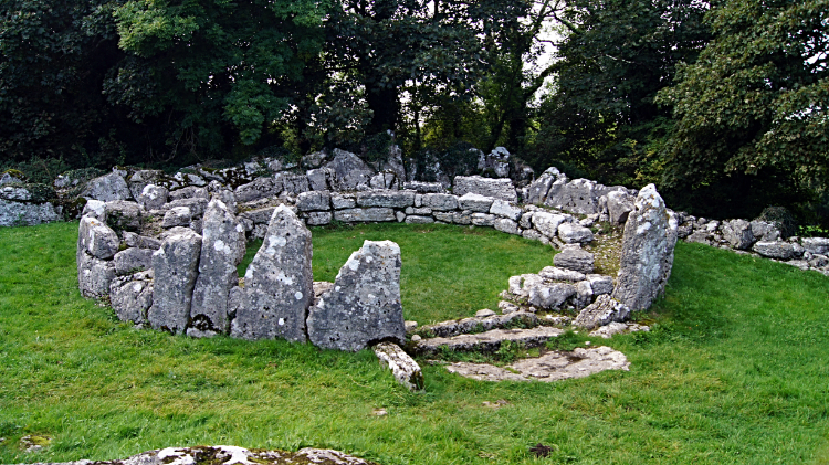 Site of a Din Lligwy hut
 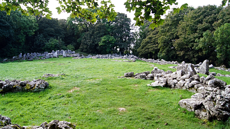 Din Lligwy
I am fascinated by history, ancient and modern. More often on historical walks I visit the sites of Norman, Plantagenet and Tudor Castles. More recent ones too and significant sites like Hadrian's Wall and Offa's Dyke. I also visit stately homes, some derelict, some still lived in. In my passion of long distance walking I sometimes walk old pilgrim paths, roman roads, drove roads and military roads too. However, during my Ridgeway National Trail walk I was fascinated by the more ancient sites, some stone age and neolithic. So to visit the site of the iron-age village of Din Lligwy was such a privilege. I emerged from the trees and entered the small clearing which is the site of Din Lligwy and stood in awe at what I could see. I was first drawn to the circular shape of an individual hut, not very big at all, around four to five metres in diameter, limestone foundations and the appearance of seating all around the inside. Perhaps for extended family gatherings or feasibly as a council chamber. I tried to imagine what might be discussed by those seated there. "Enough food to forage.. Any strangers to be wary of.. Any Romans after our stock and provisions.. What is the weather likely to be this week" Who knows. Perhaps they were good at predicting what was to come. The extended site of Din Lligwy was quite ethereal to walk around. More huts, some more rounded like the first, some square. Architectural innovation even then. All in all, my visit to Din Lligwy was enlightening and very memorable. It was a shame to leave. as I did the site returned to perfect peace.
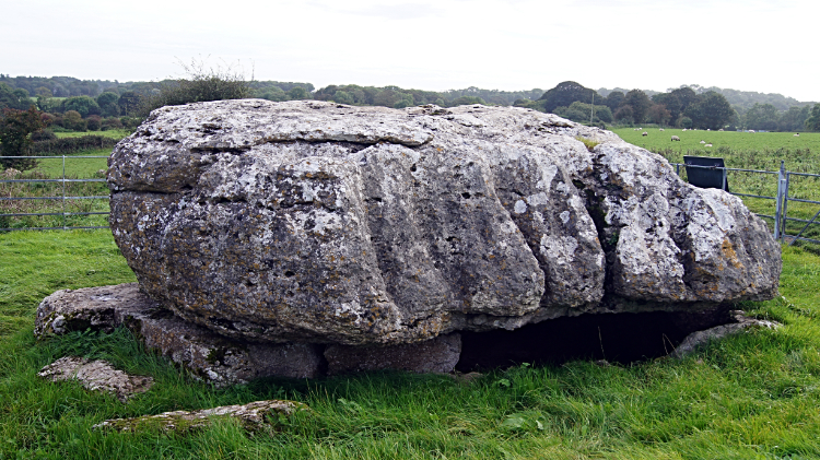 Lligwy Burial Chamber
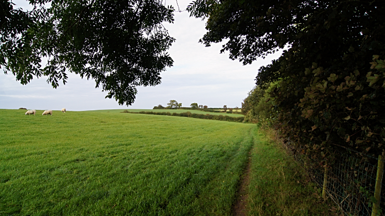 Countryside path back to Moelfre
Chapel and iron-age village done, just the burial chamber to go. Back through the wood and across a field led me to a point further down the road I had walked earlier, now following it around a corner and a few metres more to the field side where Lligwy Burial Chamber revealed itself. With eight uprights supporting the massive capstone it must have taken some putting in place, an arduous job important enough for the people undertaking the task in paying their respects to their forebears. I am humbled. Standing beside the burial chamber demands my appreciation. It is given. Like other times on this walk I have been stopped in my tracks and made to reflect. First to the sad victims of the shipwreck, then to the people who visited the chapel and the people who lived in the iron-age village. And now to those who were left to rest here. As I walked away from the burial site and across the fields of pretty countryside I thought about why the villagers had set up home here. Looking at the scene of loveliness gave me an immediate answer. It is so nice around here. Lovely coast and lovely countryside. Moelfre is a nice quiet place too, as I found out on my walk through the village back to the car. My first day on Anglesey had been magic.


